The journey of the Frome
Moira Jenkins - Wed 9 Dec 2009
This talk by Moira Jenkins of the Herefordshire and Worcestershire Earth Heritage Trust will be followed up by a Frome Valley walk led by Moira on August 5th 2010. Write up by Mary Geffen.
Her talk was richly illustrated – clearly from personal experience of the valley. It was not merely about the geology. We were told of dozens of local treasures to be seen: the ruined church; the abandoned meander; the old cider mill; standing stones and boundary stones hidden in hedges and walls; a font carved in the Hereford School style; an old and once successful canal; fossils to be found behind notice boards; stunning view-points; and so on. To discover the Frome Valley we recommend:
“The Frome Valley Discovery Guide”; ISBN 978-0-9548360-8-5: £2.00 from The Herefordshire and Worcestershire Earth Heritage Trust. University of Worcester, Henwick Grove, Worcester, WR2 6AJ. Phone 01905 855184.
The talk described a journey down the River Frome, a small river whose course is entirely within the county of Herefordshire. The talk took us down the valley from north to south, from the river’s source to its junction with the River Lugg. This journey in general moves backwards through geological time, from younger rocks (on higher ground) to older rocks (on lower ground) with occasional leaps forward to the Ice Age and then back again.
The Bromyard Plateau and the source of the Frome
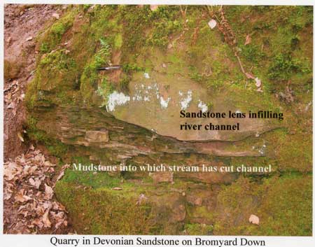
The source of the Frome is on a hillside to the north of Thornbury. The river is at first a tiny stream flowing through gently rolling countryside, part of the Bromyard Plateau, into which streams are deeply incised. This part of Herefordshire is underlain by ‘Old Red Sandstone’ rocks, Devonian in age. These rocks of the St Maughans Formation were laid down on a semi-arid land surface crossed by seasonal streams. Pictures were shown of sandstones showing 400 million year old river channels and fossil soils.
Mudstones and a muddy river.
At Bishop’s Frome the river leaves the Bromyard Plateau and flows over the Raglan Mudstone which underlies the St Maughans Formation. This rock is also ‘Old Red Sandstone’ but is Silurian in age. The rock is more easily worn away and the valley is wider and shallower. The Frome is one of the muddiest rivers in the country, coloured by the mud it has eroded from the underlying mudstone rock. The mudstone is seen outcropping occasionally as low river cliffs and sandstone bands form low waterfalls.
Ice Age gravels
Near Bishop’s Frome are gravels left after the Ice Age on low ridges. These gravels are remnants of a cold-water proto-River Lodon which flowed from north to south.
A narrow band of limestone between
Between the St Maughans Formation and Raglan Mudstone Formation is the Bishop’s Frome Limestone. This was named after the village of Bishop’s Frome and is a fossil soil layer. When conditions were stable and sediment was not deposited for a while, a soil developed and lay on the surface. In the arid climate lime-rich ground water was drawn to the surface and evaporated precipitating the dissolved lime as nodules of Calcium carbonate. If the process continued for a long time the nodules gradually grew larger and coalesced into a band of limestone or calcrete. The Bishop’s Frome Limestone is the thickest calcrete in the area, often several metres thick. It was quarried for lime for the fields.
Tectonic Plate collisions
Pictures were shown of modern day tectonic plates of the Earth’s Crust and a map of the world at the end of the Silurian Period. At this time, around 400 million years ago, two tectonic plates collided and pushed up the mountains of Wales. These mountains were then eroded by seasonal streams and the sediments deposited as the ‘Old Red Sandstone’ rocks seen in the Frome Valley.
The earlier limestones beneath
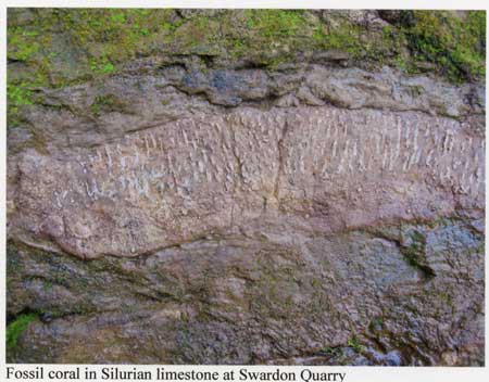
The journey down the Frome Valley then visited the earlier rocks which underlie the Raglan Mudstone Formation. These marine Silurian rocks can be seen on the Woolhope Dome and Shucknall Hill where the rocks have been up-folded into anticlines. These rocks were laid down in an ocean between the two tectonic plates before they collided. At that time this area was south of the equator . In the shallow subtropical seas limestone was formed. The seas were teeming with life and the rocks are very fossiliferous in places. Pictures of some of the fossils such as corals, brachiopods and corals were shown. Occasionally a distant volcano erupted and deposited a layer of ash which has formed a bentonite clay band.
The dry valley of the Lodon
River Lodon formerly flowed to join the River Lugg. Since the end of the Ice Age, it has been ‘captured’ by the River Frome. The former valley of the Lodon is now dry. This is the route that was followed by part of the Hereford to Gloucester Canal. Part of the canal can be seen west of Monkhide.
The Frome joins the Lugg
Finally the River Frome flows in a wide valley, through meadows to join the River Lugg. Along this stretch of the river a flood defence embankment has been built to protect the farmland on either side. You can read more about this in the Frome Valley Discovery Guide.