Malvern’s geology and Landscape
Slide 1
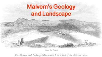
I think we’ll all agree that we live in a beautiful part of the world. An important reason for this beauty, and perhaps the main one, is the underlying variety of rocks. That is, the local geology. The differences between the rocks give the striking shape to the surface on which we live. The vegetation grows in soils which are derived from the rocks. Many of the lovely old buildings, especially the country churches, are often built of local rock.
So I think we can understand much better why the scenery is as it is if we know something of what’s beneath the surface. That’s really what I want to explore this evening. We’ll first take a quick look at some of the things that need explaining.
Slide 2
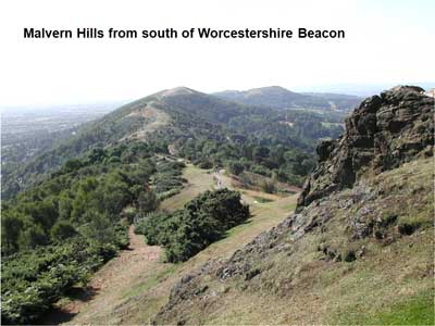
The Malvern Hills are an almost straight ridge about 8 miles long but at the most a half mile wide.
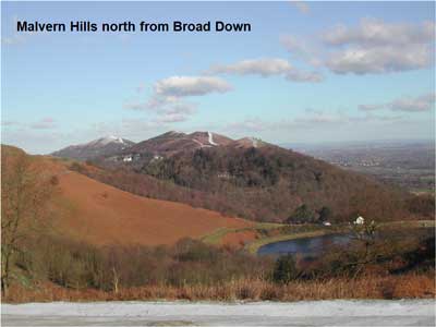
Slide 3
The view north along the ridge from Broad Down near the Herefordshire Beacon.
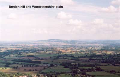
Slide 4
East of the hills a wide plain extends about 20 miles to the Cotswold Hills and a lot more into the Vale of Evesham.
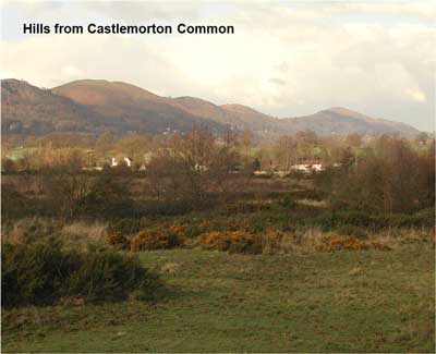
Slide 5
This shows the northern hills from Castlemorton Common down on the plain. The hills rise very abruptly.
Slide 6
This is even more apparent looking from the north. The hills rise sharply from the level plain and are really quite a small feature in the general landscape.
Slide 7
Looking west from the hills, the ground is much more hilly. From above West Malvern we can see wooded ridges winding off to the north.
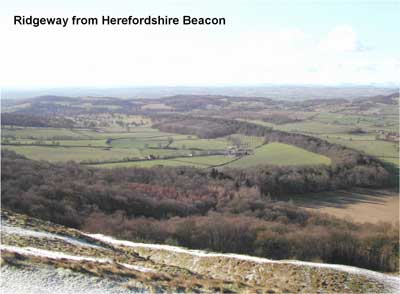
Slide 8
West of the southern end of the hills we see something similar. This is the Ridgeway west of British Camp, curving away towards Ledbury.

Slide 9
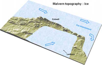
This synthetic aerial picture summarises all these features.
North-south ridge of the Malvern Hills.
Severn valley flat; a few ridges, valleys.
Western ridges - Two sharp ridges plus one to east. Ledbury hills show short lengths of paired ridges.
Slide 10
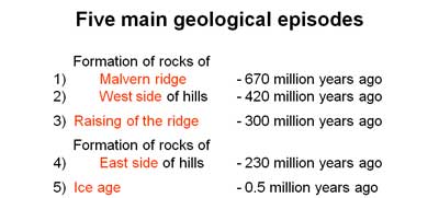
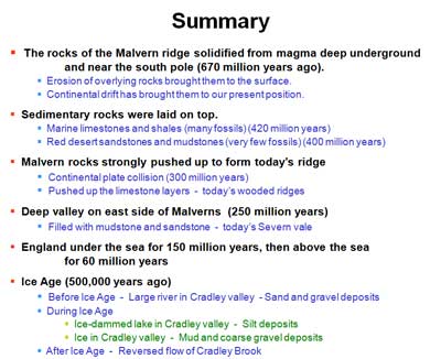
5 main episodes in Malvern's geological history.
4 from long ago. 5th is the Ice Age - details of landscape.
All of the four older events depend upon continental drift.
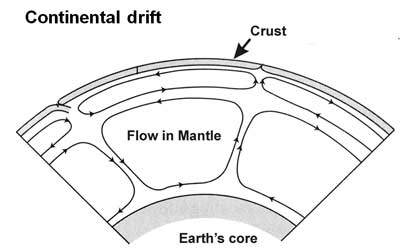
Slide 11
I imagine that probably all of you are familiar with the concept of continental drift. The idea is that the crust of the Earth is composed of relatively light rocks which float like scum on the heavier rocks beneath. The crust is in pieces called tectonic plates. They are about 10 to 30 km thick and are carried across the surface of the globe by convection flows in the fluid rocks lower down. The speed of the moving plates is roughly the same as the growth of finger nails. Plate collisions lead either to mountain building or to subduction.
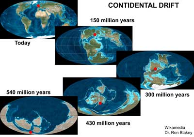
Slide 12
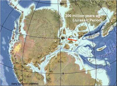
How has continental drift affected Malvern? This sequence starts with the familiar layout of the earth at present. Malvern is roughly marked with a white dot. The lower pictures show the changes going further and further into the past.
200 million years ago: 360 million years: 420 million years: 515 million years
You'll see that Malvern has drifted to its present position from one fairly near the south pole. It's taken about 600 million years to do this. During that time it's been sometimes under the sea and sometimes above sea level. It's been in all sorts of climates from tropical to glaciated. It's generally been quite near the edge of its continental plate and so has felt quite strongly the effects of plate collisions and breakages. So there's no wonder that this area, like Britain as a whole, has a great concentration of varied geology.
Slide 13
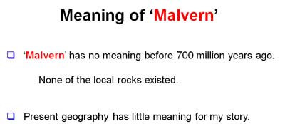
We've arrived at a period about 700 million years ago. The geological history of Malvern is meaningless beyond that time; the rocks didn't exist. This clears up at once an erroneous statement that's sometimes heard, that the Malvern rocks are the oldest in the country. They are actually among the oldest in England and Wales. The rocks of north west Scotland are about four times older, at about 3000 million years.
Let me enlarge on that point. What I call 'Malvern' really means the rocks of the Malvern Hills and whatever surrounds them at any particular time. You mustn't even try to think about it in terms of everything we see now. Most of it wasn't here until relatively recently. It was lying around as an altogether different rock somewhere else on the Earth, before being eroded and brought somehow to the neighbourhood of the Malvern rocks where it consolidated into new rock.
So the geography of the area has generally been quite different from what we have now, except that for most of the time there has been some form of hills locally.
Slide 14
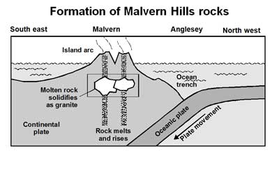
This diagram tells how the Malvern Hills rocks were formed. It shows a so-called subduction zone where a continental plate and a lower oceanic plate are colliding. Let me emphasise that this happens very slowly indeed. The heavier one is forced down under the continental plate. As it goes down it gets hotter and can partly melt. This molten rock can work its way upwards and commonly forms a chamber, which it fills, deep underground. Sometimes it may solidify slowly where it is. In other instances it may find a way to the surface and become a volcano. All of this is just what's happening around the rim of the Pacific Ocean and elsewhere today. Earthquakes occur because the motion of the plates against each other is not smooth. This led to the tsunami a couple of years ago.
The Malvern Hills are what remains of one of these molten rock chambers. It formed and solidified perhaps 20km down and has since been brought to the surface by further plate movement and erosion. Whether there was ever an associated volcano isn't known. So although the Malverns are made of rocks which are loosely called volcanic rocks, it is quite wrong to say that the Malverns are old volcanoes. The rocks are more accurately described as igneous.
I've got a few examples of these igneous rocks which you can look at later if you like.
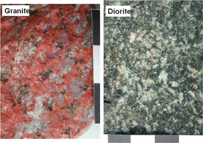
Slide 15
These are typical rocks of the Malvern Hills. Colloquially they are all called granite but they have a range of technical names. You can see that some of them consist of interlocking crystals. The granite especially shows this and the large crystal size shows that the molten rock cooled very slowly, possibly over millions of years. This is consistent with it being deeply buried. There are three main minerals here. Pink stuff called feldspar. There's a black mineral. This could be any of a wide variety but it's dark because it contains a lot of iron or magnesium. The last mineral is a grey one. This is quartz, which is silicon oxide. All of these minerals are silicates of one sort or another.
The diorite is similar to granite but has much more of the dark minerals and very little quartz. Most of the Malvern rock is diorite.
Granite and diorite were formed in deep underground chambers as I've described. This is confirmed by the relatively large size of the individual crystals, about 5mm. Large crystals form when the solidification is very slow.
When the rocks had solidified, other things happened. They were still in a pretty violent place. Deep in the Earth and very hot but now solid, they were still being subjected to the original continental collision. The enormous forces involved caused some of our rocks to be distorted and changed chemically.
Slide 16
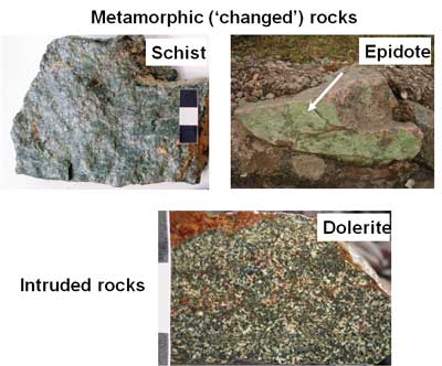
The left hand picture here shows a rock to which this has happened. It's called a schist. This one's from the south end of the hills. You can see that it now contains a lot of shiny mica. The thin plates of mica are all lined up parallel to each other, telling us that the pressure was applied perpendicular to this. This is an example of a metamorphic rock, one that's been altered from its original form. Another metamorphic chemical that we see a lot of in the local walls of Malvern stone is epidote, which is a light apple-green colour. This is the right hand picture. This forms as the result of the movement of superheated water with lots of dissolved chemicals under high pressure along cracks or joints in the rock.
There were other violent happenings in these early Malvern rocks. Although granite is a very tough rock, it was weakened by all the disruption I've just described. This allowed smaller quantities of still-molten rock to force its way along cracks and to open them further before solidifying in its turn. This process is called 'intrusion'. Because the intruded rock is surrounded by relatively cool rock, it solidifies quickly and this results in crystals of very small size. You see this in the bottom picture. This rock is called dolerite and you find in bands all over the hills, especially in the northern half. A well known example is the Ivy Scar Rock.
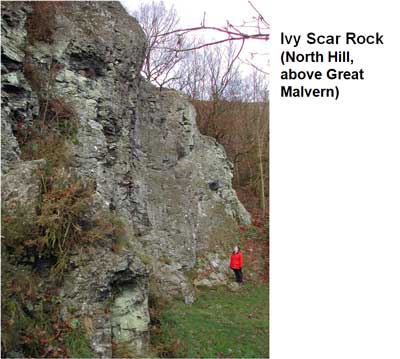
Slide 17
Ivy Scar Rock is perhaps the largest of the exposed intrusions.
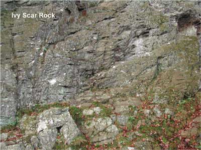
Slide 18
This picture shows flow lines in the rock from when it was
still just fluid and moving under high pressure.
That's the first of my five geological episodes, the formation of the igneous rocks
of the Malvern hills. This was 650 million years ago. A hundred million years
later on, erosion had exposed the Malvern rocks at the surface. We know this
because we find the erosion products around Midsummer hill and Raggedstone
hill. At the same time the rocks were on a small tectonic plate which drifted
north.
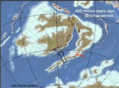
Slide 19
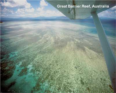
At about 420 million years ago the rocks were about thirty degrees south of the Equator, on the edge of a shallow sea. The environment was much like that of the Australian Barrier Reef today. Coral reefs flourished. There was abundant sea life. You might imagine the hill in the distance to be early Malvern hills.
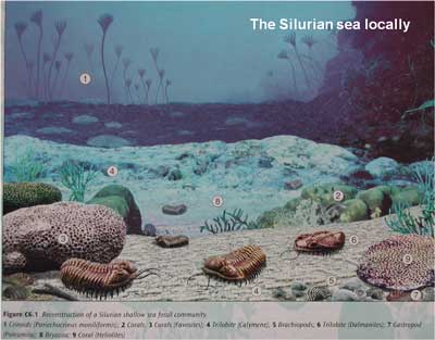
Slide 20
Shell fish of many sorts were abundant, including these long extinct creatures called trilobites. All of the others shown here are from families that have lasted until the present day, snails, bivalves, brachiopods, crinoids.
Slide 21
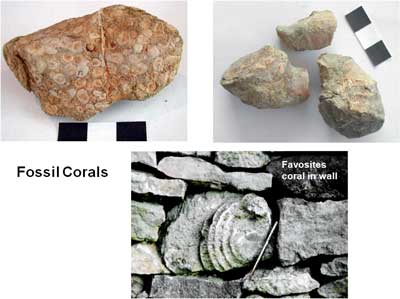
Fossil corals found locally.
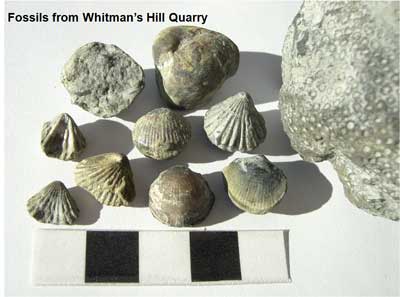
Slide 22
Brachiopod shell fish and a coral.
Slide 23
The water was rich in dissolved limestone and, with the shell and coral remains, this formed layers of limestone laid down in horizontal beds. In between times the sea got deeper and life on the sea bed wasn't possible. Then silt or mud was deposited and in time formed layers of darker shale. We were left with alternating horizontal layers of limestone and shale which today are the rocks on the west side of the hills and in the Alfrick and Suckley hills to the north.
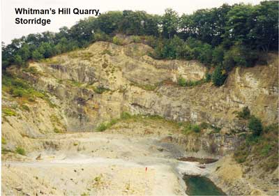
This is Whitman's Hill quarry, on the hill just this side of Storridge. It’s now a geological reserve run by the Earth Heritage Trust. You can see the thick limestone layer at the top. The lowest part is shale. The layers are now tilted from the horizontal and how this came about is in the third part of our story. Before reaching that though, I mentioned before that the Malvern Hills were at the edge of a sea. We know this because parts of the actual beach from that time can still be found around the hills.
Slide 24
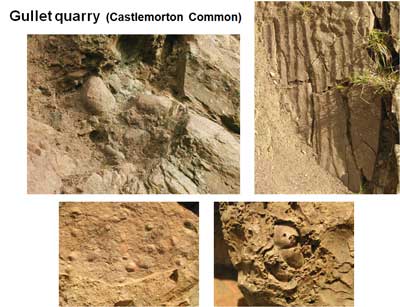
The best view of the beach is at Gullet quarry. It was mostly dug out by the quarry people in the 1960s but a little bit remains. You can see the pebbles of the old beach. These fell from the adjacent Malvern hill as rough rocks and were then worn by the sea to their rounded shape. They are cemented together now, and sea shells are found with them. Researchers in the past have identified ancient rock pools and small sea stacks here.
Nearby, on sandstone faces, you can see ripple marks left one day by the receding tide which were for some reason quickly covered by mud or silt and preserved for 400 million years. They are now vertical because of later earth movements which I’ll explain later.
There are lots of fossils too, but you don’t find the shells, only casts in the sandstone. The limey material of the shells themselves has been dissolved away.
In a similar way, there are the hollows left by sea shells which rested on the sandy sea bed.
Slide 25
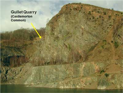
This shows the location at Gullet quarry, high up on the west side of the main face. It's quite a climb to reach it. If you go there, please, please don’t disturb any of the rocks still in place. This is a very important site for geologists and there’s very little left of the old beach.
Gullet quarry is probably the most interesting site in all the Malverns. Apart from the sea shore, the schist rock I showed came from there. I hope you can see these pink vertical bars low in the rock face; these are intruded rocks.
Slide 26
Let's take a look of the geography at this time.
This shows what it’s thought to have been. The brown is land, light blue is shallow sea and dark blue is deep sea. To help us, the present political boundaries and coasts are marked.
England's about here. The small plate it’s on was drifting slowly north towards this large one at about a couple of centimetres a year. After ten million years or so, the ocean was closed and the continents collided. I emphasise again the slowness of this event.
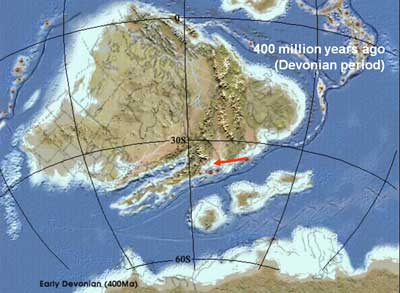
Slide 27
Mountains resulted from the collision and our part of the world was left well inland, now above sea level in a hot semi-arid region with intermittent rivers from the mountains to the north running to the sea to the south. Erosion debris brought from the mountains was laid on top of the marine limestones and today gives the red soils and rocks of Herefordshire.
Slide 28
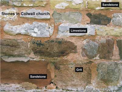
If you want to see these different rocks, a good place is often the walls of the old country churches. The builders seems to have used any suitable rock they could get hold of..
This is from Colwall church.
Marine limestones are light grey.
The yellow sandstone is from the shallow seas when the land was just emerging.
The red sandstones are from the later arid desert.
Sometimes flash floods brought larger material on to the plain to give us the grits.
Slide 29
During the next hundred million years we drifted further north, into the tropics, and saw the prolific vegetation which gives us today’s coal from the tropical swamps.
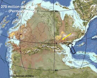
Later on, we suffered another continental collision. This time the collision was from the south. A mountain range of Himalayan size was thrust up, running from what’s now France into central Europe. This had some strong effects locally. Firstly this area was far from the sea and was near the Equator. From being a swamp, it became a desert again.
Slide 30
Secondly, there were some local mountains generated close to here over what is now the Severn valley
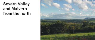
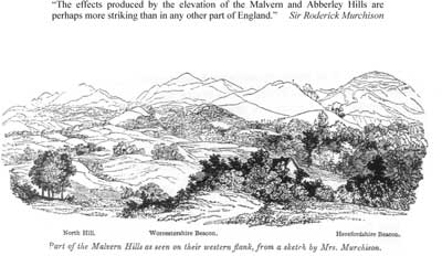
To understand this, we’ll return to this peaceful view of the Malverns from the north. I want you to imagine the Earth cut open along an east-west line through North hill and all the foreground removed. What you then will see is shown schematically here.
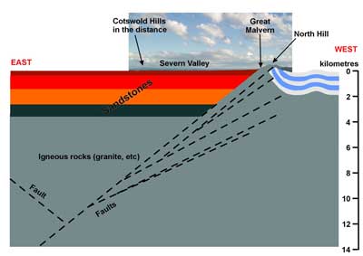
Slide 31
What we have is the Seven Valley filled up with mostly sandstone, the layers of marine limestone and shale on the west of the hills and all of it underlain by igneous rocks, probably like those of the Malvern hills.
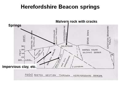
Also you can see this diagonal feature. This is a geological fault. That is, it’s a break in the rock and so it’s a line of weakness. This is called the Malvern Fault and it extends north into Cheshire. To the south it can be traced, deep under other rocks, as far as Weymouth. It extends very deep into the Earth’s crust; 14km is shown here. It dates nearly back to the formation of the Malvern rocks. It’s thought to be where two small plates collided and stuck together about 600 million years ago. It’s one of the major structural elements in England because it separates the essentially flat Midlands from the hills of the Marches and Wales to the west.
In the latest continental collision, which formed the old European mountains, a side effect was that the ground in our region was compressed east-west. The rocks to the east were pushed up this inclined plane to a great height to form mountains about 2000m high over where the Severn valley now lies. It also compressed the surface rocks to the west, rumpling them like this. Again, this all happened very slowly. If you had been there you would have experienced occasional earthquakes, but that’s about all.
Over the following millions of years, the mountains were eroded down to flat ground. After this, the east-west compression changed to an extension. A second inclined fault opened to the east. As the two sides were drawn apart, the wedge of rock in the middle slowly sank into the void. The faults are not clean breaks. They are, rather, multiple breaks as I’ve shown. As it happened, some of the slivers of igneous rock stayed in place and one of them forms today’s Malvern ridge. The sunken rock formed the floor of a great valley. Of course, a large hole in the ground eventually fills up with the debris from its surroundings. That’s what happened here too, initially pebbles and sand, then just sand and finally mud which now forms the base rock around here.
Slide 32
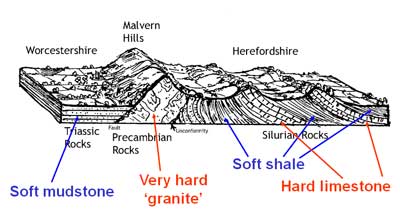
We saw how the rocks to the west of the Malvern hills were bent by earth movements. After the long cycle of erosion this has left us with the general topography shown here. This is a cross-section looking now from the north. The hardest rocks, those of the Malvern Hills, form the highest ridge. The edges of the upturned limestone bands to the west form the pair of sharp ridges parallel to the hills. What isn’t shown here is a lower sandstone band which forms the third, and broadest, of the three north-south ridges. The upturned shales are in the fertile vales. To the east are the relatively undisturbed horizontal layers of soft mudstone.
Slide 33
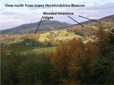
This view from the top of Chances Pitch looking towards Colwall shows again the limestone ridges. You can easily pick these out because they are well wooded. The vales formed in the softer shales have deep fertile soil and are farmed.
Slide 34
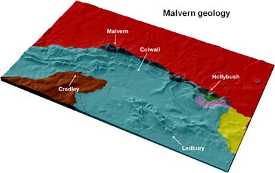
This is another picture of much the same thing. It’s the earlier topographical map but now with the broad geology superimposed.
The Malvern hill rock is shown as black.
The blue area shows the Silurian limestones and shales deposited in a coral sea and since distorted to gives a series of ridges and vales. It extends all over the lower left part of the map, of course, but has this bit of reddish-brown rock sitting on top of it. This is the red Herefordshire sandstone from Devonian deserts. These are the hills beyond Cradley.
(Here, mauve and green, are some small areas of pre-Silurian rock seen, as it were, through a small window. The yellow area is rock formed from the erosion debris of the upthrust eastern mountains.)
The large bright red area is the Severn valley, the old rift valley, filled in with a couple of kilometres thick mudstone and sandstone.
That describes all the underlying rocks around here. But it’s not the end of the local geological story and for that we will have to move forward 200 million years, nearly to the present day. In fact to the time half a million years ago, just before large glaciers over-ran this area in the Ice Age.
Slide 35
Let me briefly fill in the missing 200 million years though. At the start of the Jurassic period, this area was again submerged in the sea and so it stayed for 150 million years. Huge thicknesses of limestone and chalk were formed which completely covered much of this island. The final rock surface would have been several hundred metres above where we sit now. But 60 million years ago this was all raised above sea level once more and it has since eroded away to give the landscape of today. The nearest to here that some of these rocks still exist is in the Cotswold hills.
And then, 2 million years back, the Ice Age began and it brought about some interesting changes in the local landscape.
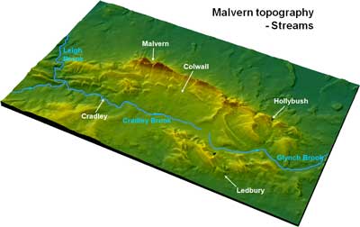
Slide 36
So, back to this diagram. It now shows the main streams on the west side of the hills. These are the Glynch Brook flowing south past Eastnor to join the river Leadon and then the Severn near Gloucester. Secondly, the Cradley Brook which flows north and eventually joins the river Teme and then the Severn near Worcester. Both rivers are small. The Cradley brook in particular follows a strange route, starting in flat low ground but passing through a large, meandering valley between high hills formed by the limestone ridges at Longley Green. How did this small stream, ‘break through’ this high ground?
Geologists often get clues to this sort of problem by studying the surface deposits. The surface deposits are the debris from relatively recent erosion. This is spread in a thin layer over a lot of the solid rocks I described earlier. By ‘thin’, I mean from zero up to about 30 metres. Study of this debris can tell a lot about the latest history of the area, for instance ice ages and the ancient courses of rivers. This has been a fruitful research area in both the Severn and Cradley valleys during the past twenty and more years.
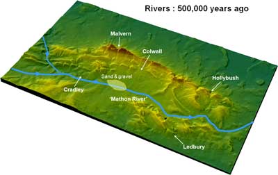
Slide 37
The Cradley valley studies show that half a million years ago there was a large river flowing from north to south in this valley. It followed roughly the present river courses. The river near Cradley flowed in the opposite direction to today. The river, or a large tributary, flowed into the area through the gap at Longley Green from the Severn valley. The fact of the river is known from the sands and gravels which were extracted until fairly recently from various pits around Mathon. It’s known as the ‘Mathon river’. At this time the river Severn was not the major river it is now so it’s possible that this stream drained a large part of the north Midlands. Also likely is that the river joined with the north-south Teme valley north of Knightwick. These ideas follow from the pebbles in the gravels; most of them can be identified with their areas of origin to the north of here, Staffordshire, the Clee Hills, and so on.
The river probably had this form.
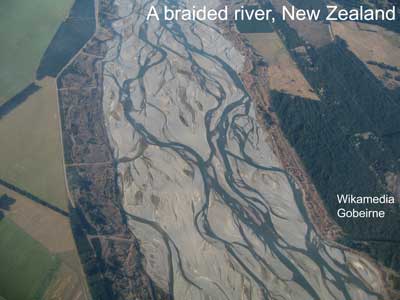
Slide 38
Braided streams like this one are typical of fast flowing streams carrying a lot of sand and erosion debris. The Mathon river may not have been this big though.
The study of animal and vegetable remains in parts of these gravels has allowed a general description of the area at that time.
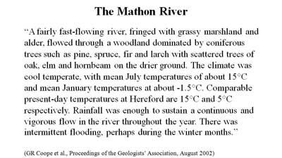
Slide 39
It’s not too different to today except for considerably colder winters.
Slide 40
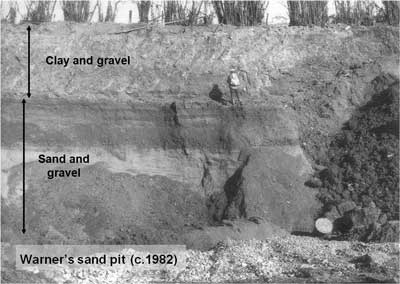
This is the old Warner’s sand pit. About 6 metres of sand is overlaid by 4 metres of later clay and gravel. The sand was brought here by the Mathon river. Missing from here, but occurring in many other localities, is a thick layer of silt. The experts identify this as being deposited when the river entered a lake. So now we have not only a large river but also a subsequent lake occupying the Cradley valley. What dammed the river to cause this?
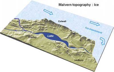
Slide 41
The answer is Ice. This is the general picture at about 450,000 years ago. A large glacier moved south on the east side of the hills and a part of it is thought to have turned around the south end of the hills and blocked the Mathon river. A lake formed upstream and the finer material which it carried was now dropped to the lake bed on top of the earlier sand. This bed of silt is about 25 metres thick in places.
I have to stress that this map is just figurative. The details are far from accurate. No one knows any of the details.
Slide 42
Later on, more ice came into the district, probably from the west but maybe from the north. It perhaps covered the whole area. The moving ice carried its own load of debris which it had scraped from the ground elsewhere and it eventually dropped this load on top of the lake silts. We know that this ice came from the northwest because it carried rock fragments from Wales and west Herefordshire. In time the ice front melted back, leaving ground which alternately froze and thawed. Under these conditions, the mud can move downhill on quite gentle slopes, so a consequent mixture of clay and fragments of local rocks is now laid on top of everything else on quite large areas all around the Malverns.
So, we’ve had four very distinct episodes of deposition in the Cradley valley – the sands from the Mathon river, the silts in the ice-dammed lake, the so-called ‘till’ brought by the glacier and lastly the so-called ‘solifluction’ deposits of local material from the higher ground. No wonder that the valley floor is quite different to that of half a million years back.
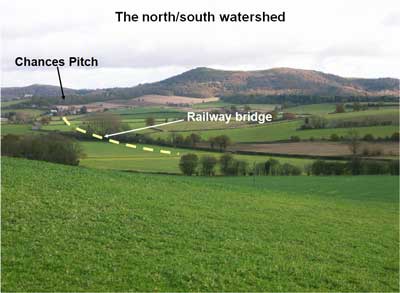
Slide 43
It’s turned out that the highest ground in the valley floor after the ice left was near the bottom end of Chances Pitch, just about at the location of the present railway bridge on the road to Ledbury. So from this seemingly uninteresting piece of ground the Cradley and Glynch brooks flow off to north and south respectively, while underground lie layers of river sand, lake silts and glacial debris representing the whole Ice Age history of the valley.
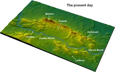
Slide 44
So here again is the present day situation, with the streams lying in their rather strange configuration.
There was a much more recent advance of ice, about 10,000 years ago, but the ice reached only to Birmingham in the north, and Hereford in the west. This did generate some major changes in the river courses in the Midlands. That’s another story though. There were not large changes here.
Slide 45
Read the summary.
(A number of people have requested copies of the summary as an aide memoire. Do supply anyone who asks.)
Slide 51
No comments
Slide 46
No comments