Introduction to the Geology of the Peak District
Alan Gray – 10 October 2012
Background
Alan’s talk was associated with a three day trip by a party from the Geology Group to Buxton in September 2012 (click here for a write up of this trip). An earlier version of it was given to the party before the trip and this expanded version was given to the whole Geology Group after the trip.
Geological Evolution of the British Isles
Alan started by summarising the evolution in time of the position and environment of the British Isles from the Cambrian to the present in order to set the background to how the complex geology of the Peak District came about.
Under Plate Tectonic action the British Isles have moved from close to the South Pole to where we are now. By the Ordovician Era (450 mya) the British Isles (less Scotland and Northern Ireland) were on the southern edge of the closing Iapetus Ocean about 30 deg south of the equator. By the Silurian era (425 mya) the Iapetus Ocean had closed and the collision of Avalonia and Laurentia closed the gap between England + Southern Ireland and Scotland + Northern Ireland.
This collision of plates resulted in the Caledonian Orogeny and the creation of the Caledonian mountains. These mountains were originally on the same scale as the Himalayas. They have since eroded and split into the present day Grampian Mountains and the Appellation Mountains in North America separated by the Atlantic Ocean.
By Carboniferous times (302 mya) the fusion of the British Isles was complete and in the Triassic era the Atlantic Ocean began to open up.
During all this time sea levels had risen and fallen many times and the components of the British Isles were either under water or on dry land. The immense Tectonic forces had also folded and faulted the rocks resulting in the present geology of the British Isles and in particular the Peak District.
Peak District Geology Overview
Modern attempts to understand the geology of the Peak District started in the 18th century but until the ideas of Plate Tectonics were developed in the mid-20th century no real understanding was possible.
In broad terms the Peak District can be divided into ‘White Peak’ country in the South and the ‘Dark Peak’ country in the North. The White Peak country is characterised by pale Limestone forming rolling hills and farmland. The Dark Peak country is characterised by darker Sandstones, Marls, Millstone Grits and Shales forming more rugged and mountainous terrain.
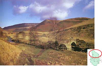
Dark Peak Country.
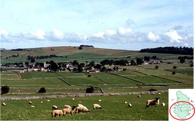
White Peak Country.
To the East and West are coal measures formed in the Carboniferous era. Mineral solutions from the North Sea and the Cheshire Basin have permeated the limestone in the South and formed extensive and varied mineral deposits. These coal and mineral deposits have led to the Peak District mining heritage.
During the Variscan Orogeny (~290 mya) there was a massive uplift of the whole Peak District area forming a huge anticline dome. Subsequent weather erosion completely removed the rock and coal measures at the top leaving the present deposits only in the East and West. This erosion left the older underlying limestone which we see today.
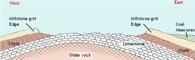
Cross section.
Formation of Rock and Mineral Types
Between 350 and 325 mya the tropical environment was deep underwater basins interspersed with reefs surrounding calm shallow lagoons. There was also some volcanic activity. This led to the deposition of shells, stems and calcium carbonate with hot molten rock being forced up in places. This resulted in the formation of limestone with basalt and dolerite sills.
Between 325 and 300 mya the environment changed to a large river delta. Grit and mud were deposited leading to the formation of Gritstone and Shale.
From 300 to 280 mya there was a massive uplift and no new sediments were deposited. The associated Tectonic forces cracked, folded and faulted the existing rocks.
Around 280 mya further Tectonic activity led to hot liquids filling these cracks and faults. These liquids then cooled to form mineral veins in the Limestone of Calcite, Galena, Fluorspar and Barite.
In the more recent Pleistocene era (2 mya) the higher Gritstone rocks were eroded by weather and four Ice Age periods exposing the underlying Limestone. Acidic Loess was deposited in the hollows of the Limestone. The present landscape has resulted from later erosion leaving a limestone plateau incised with steep, often dry, valleys left behind by glacial melt waters.
The early Carboniferous seas had an abundance of sea animals and plants which have left behind a rich variety of fossils in the Peak District sedimentary rocks. For reasons not fully understood fish fossils are quite rare.
There is evidence of ‘Turbidity Currents’ occurring in submarine canyons in Carboniferous seas. Turbidity Currents of mud and silts flowing down submarine canyons resulted in graded bedding of deposits at the entrance to the canyons with coarse material at the bottom and fine material at the top.
This led to the formation of Turbidites which can readily be found in the Peak District.
The submarine canyons and gorges themselves are still there as can be seen, for example, at Winnats Pass.
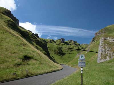
Winnats Pass looking West.
Limestone transport occurs when it is dissolved in acid rain (Carbonic Acid) and flows in rivers and streams. Subsequent evaporation of seeping water reverses the chemistry and the limestone is reformed as ‘Flowstone’ (Calcite), stalactites and stalagmites. There are some good examples in the Peak District in Treak Cliff Cavern and Peak Cavern.
The dissolving of the original limestone leaves behind a characteristic ‘Karst’ landscape with limestone pavements and sink holes.
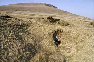
Sinkhole: Mam Tor - Windy Knoll.
Peak District shales are found between the upper Millstone Grits and the lower limestone. Shales are generally very weak rocks and when wet are soft and slippery. When exposed they will tend to slide down the prevailing terrain. Examples of this can be seen at places like Edale. Dramatic folding of the shale can be seen at Rowlee Bridge (Ashop Valley) which looks like the result of tectonic forces. However this folding is simply caused by the shale slumping down a valley.
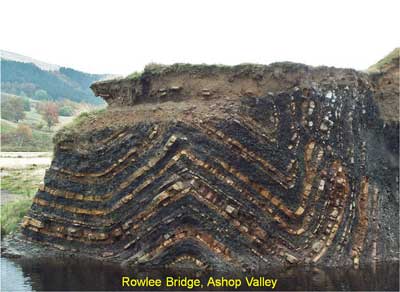
Folding: Weak Namurian Shales.
Millstone Grit can be found all over the Peak District and indeed is used for millstones! Good examples of Millstone Grit cross-bedding can be found at Kinder Scout southern edge. The cross bedding is caused as the Millstone Grit was laid down in broad and shallow braided streams with changing cross currents.
Coal measures were produced in the Carboniferous swamps. The Peak District coal measures have been mined for hundreds of years as they were easy to reach being near or on the surface in many places. Seatearths (Fireclays) can be found below the coal measures. These are formed when plant roots remove Sodium and Potassium from the ground.
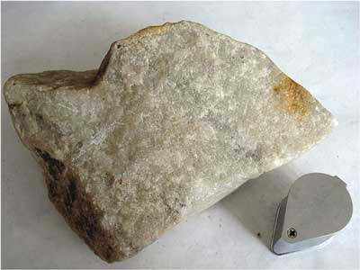
Rock types in the Peak District – Metamorphics.
Bitumen deposits can also be found where they exude through limestone from the underlying shales. Such hard bitumen deposits, known as Elaterite, can be found at Windy Knoll.
Lava flows can be seen south of Castleton. The associated Volcanism is believed to be a ‘within-plate’ process in the old Laurussian continent occurring where the Lithosphere thins in an effect known as ‘Back Arc Thinning’ some way from the plate collision boundary. Molten rock from the mantle can then force its way through faults and cracks in the thinned Lithosphere. Examples of this can be seen Carlton Hill Quarry, Litton Dale, Monsal Dale and Upper Millers Dale. Where the limestone came into direct contact with the molten rock it has been metamorphosed into a ‘Sugary Marble’.
Clays formed from volcanic ash (Tuff) can be seen as thin beds in the limestone at Carlton Hill Quarry. These clay bands are known locally as ‘Wayboards’.
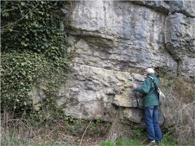
Wayboard: Millers Dale.
Mineral deposits abound and include Lead Sulphide (Galena), ‘Blue John’ (Fluorspar), Copper compounds with Lead and Sulphur (Chalcopyrite CuFeS2), Black Marble (Bituminous Limestone), Sphalerite (ZnFeS), Barite (BaSO4) and Fluorspar (CaF2). Many other minerals can be found too numerous to mention!
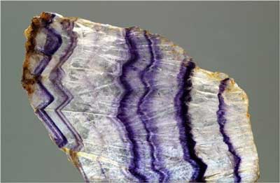
“Blue John” – Fluorspar.
Dick Harris
Click here to return to home page.