Cambrian and Ordovician Rocks of the South Malverns
A talk by John Payne on Wednesday 11 Jan 2012
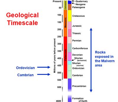
The Cambrian and Ordovician rocks of the South Malverns were laid down between 540 million and 440 million years ago, and they span a period of a hundred million years.
These rocks have a rarity value, for there are very few exposures in England. We are fortunate in this area, because the Vale of White Leaved Oak is known as ‘The Cambrian Vale’ due to the exposures here. They are in an area enclosed by Gullet, Bronsil, Howler’s Heath, Chase End Hill and Hollybush.

Why are they here? Circular structures occur in the Silurian, old dome structures. If the top gets eroded, it leaves a ‘window’ on the Ordovician and Cambrian beneath. John speculated as to whether the Woolhope Dome will go the same way eventually.

The sections depicted in the maps of the Geological Survey show that Ordovician and Cambrian rocks continue underground beneath Herefordshire, increasing in thickness as they go.
The rocks were laid down horizontally, then, near the Malverns, tilted upwards by further earth movements. There is evidence that the Ordovician rocks were eroded before the later Silurian was laid down on top of them. This does, of course, lead to an unconformity. Volcanic intrusions came from underneath during the late Ordovician.
It is a tribute to the geologists of yesteryear that the geology map of the area drawn in 1902 is still the most accurate more than a hundred years later!
In our area, there was not much movement during Cambrian times. But during the Ordovician the continent of Avalonia detached itself from Gondwana, drifted north and eventually collided with Laurentia.
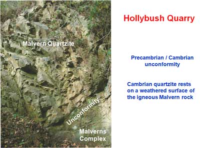
When the rocks of Hollybush Quarry were laid down, this area was moving from land to sea. There is a Precambrian/Cambrian unconformity here where the ancient Malverns Complex is overlaid by Malvern Quartzite.
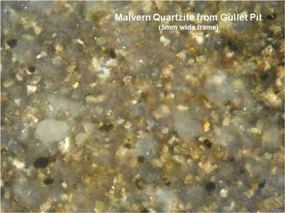
Malvern Quartzite is the base rock of the Cambrian system. It is a sandstone cemented by silica, with bands of conglomerate formed from local pebbles. The sand grains are very pure, uncoated and well-rounded indicating a beach or shallow sea deposit.
Local exposures occur at Ragged Stone Hill (2), Midsummer Hill (3), Cowleigh Park and Martley.
Hollybush Sandstone formed on a shallow sea bed as the sea rose further. It is about 250m thick locally, is a grey or brown colour, and contains crystals of glauconite. These form in seawater at a temperature between 10°C and 15°C and are a distinctive blue-green colour. Hollybush sandstone contains few fossils.

Local exposures occur at White Leaved Oak Lane (3), Ragged Stone Hill and Hollybush (3).
White Leaved Oak Quarry is at the south-east corner of Ragged Stone Hill. In this quarry can be seen an unconformable junction with Precambrian rocks.
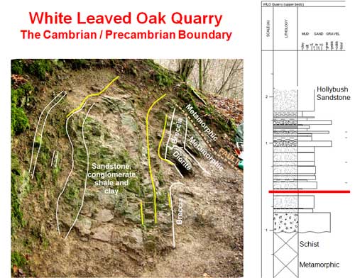
Here is to be found the transition from Malvern Quartzite to Hollybush Sandstone. There is soft sediment deformation. The lithologies range all the way from clay to conglomerate. The base sandstone, unusually, contains near-spherical quartz grains, Malvernian fragments, fine sand and many voids.
This quarry is significant historically for two reasons:— the Precambrian age of the Malvern rocks was proved here, and the theory of dynamic metamorphism was established here. (This is a form of metamorphism that causes the structural and chemical alteration of rock through pressure and temperature caused by local tectonic movements. The extreme pressures associated with mountain building can cause this type of metamorphism.)
John emphasised that “the land is bobbing up and down all the time”! When it is under water there is deposition, when it is above water there is usually erosion. Cambro-Ordovician Shales formed in deep water where they were oxygen-starved. They are of great thickness and wide extent, but rarely exposed.

Due to the lack of oxygen, the organic matter didn’t fully decay and the outcrops are usually black in colour. They contain a high concentration of uranium. Fossils are chiefly small trilobites. Gas can be extracted from the shales by a process known as “fracking”. This is a controversial technique because, it is claimed, the process can cause small earthquakes to occur.
Bronsil Shale formed in even deeper water, even more oxygen-starved, but is generally a lighter, grey colour.

John explained that the pre-Variscan Worcester Graben was an active structure well before the Carboniferous times. The Malvern fault is therefore very ancient, and John speculated that perhaps the other side of the graben was too.
Volcanic intrusions penetrate the late Ordovician layers in the south Malverns, but not the Silurian. Therefore it is concluded that they are Ordovician in age. They are a distant effect of the widespread Ordovician volcanism in west Wales. Dykes, sills and laccoliths (magma that has been injected between two layers of horizontal rock causing the upper one to dome) can all be seen. Three petrologically distinct classes of rock occur in the intrusions, therefore it is inferred that there have been three distinct phases of intrusion. In some of the rocks potassium has been partly replaced by sodium. This demonstrates contact with, or proximity to, seawater.


Local exposures occur at Westfields Quarry, near Hollybush, near the summit of Ragged Stone Hill and there is an intrusive boss below the obelisk on the Eastnor estate.
Thank you, John. We look forward to the field trip when we can see the outcrops for ourselves!