Late Ordovician Glaciation
A synopsis of the talk by Prof. Bill Fitches held on 9th January 2013.
“Late Ordovician Glaciation, Oil and Gas Formation in North Africa”
Oil and gas are sourced from the Lower Silurian Shales: Bill elucidated how such Shales were formed during the Ordovician and Silurian periods.
All the sedimentary Cambrian, Ordovician and Silurian rocks sit on top of the Precambrian granites, gneisses, etc.
The most significant amounts of oil and gas in North Africa; found in Algeria, Libya and Morocco, were discovered at the Ordovician/Silurian boundary.
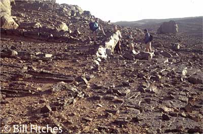
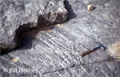
Bill introduced his talk by telling us a little about his work-history in North Africa, illustrated by slides of beautiful pictures of sand dunes. At 800km from the coast were found cave paintings of cattle suggesting farmland savannah; approx. 8.000 BC. We saw that the rocks of the Lower Palaeozoic were deposited in very level layers building up to about 3,000m; the Cambrian and Ordovician rocks being deposited in a shallow marine sea spreading south for approx. 1,000km. The streams flowing into the sea gave rise to fluvial sandstones. Proof of a warm sea is given by the beds of Skolithos in the cross-bedded Cambrian sandstones. Unfortunately the Skolithos impressions can’t be used for dating the sandstone.
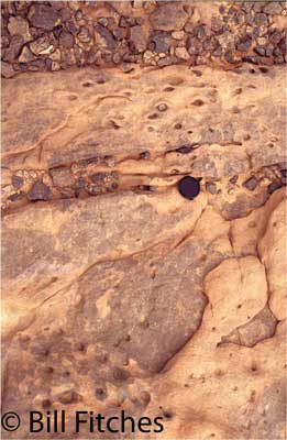
Cambrian sandstone with Skolithos burrows, Taini Ravine.
In the Late Ordovician, (Hirnantian) a huge climate change set the stage for global glaciation. An Ice Sheet covered an extensive area. Plate Tectonics of that time show landmasses arranged in respect to the South Pole, which then was somewhere near where Mali is now - North Africa was over the South Pole and moving north. During glaciation, - over a 2M year period - water was sucked out of the seas, (whose level dropped 150m), and changed to ice.
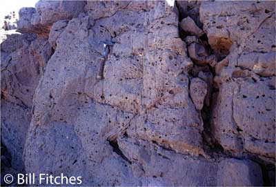
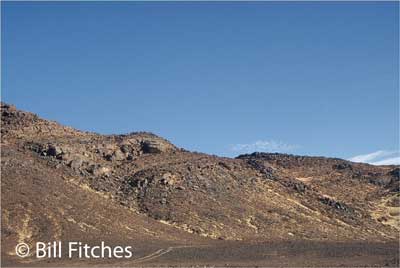
During the Ordovician the land uplifted, the ice receded, the melt waters gouged out palaeovalleys, cutting down through successive rock strata to the older Palaeozoic rocks. The valleys filled with sandstone sediments washed down by the glaciers. Bill’s slide showed us a good example of Palaeovalleys in the Tassili North Ajjeers Distribution and Orientation of S.E. Algeria. There was an unconformable relationship between the Upper Ordovician (Tamadjert Formation) and older rocks in the Tassili N’Ajjers.
The palaeovalleys were filled first by late Ordovician coarse grained sediments (mostly sands, pebbly mudstones) with high porosity and permeability that make them good reservoir rocks for oil and gas. In the latest stages (early Silurian) the remnant palaeovalleys become sites of deposition of shales/mudstones that contain organic ingredients suitable for generating oil/gas. Generally the palaeovalleys (which are much sought by geologists hunting oil shales) have: uniform orientation of NNW – SSE, are spaced 1.5 – 15km apart, can be a few km long, and are 100m – 200m from valley floor to crest.
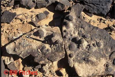
Under the continental ice sheet, known as the Late Ashgill glaciation of North Africa, all kinds of sedimentary sandstones were deposited underneath the glacial ice as it overhung the continental shelf: ice contact deposits, glacial outwash fans, submarine fans, and iceberg rafting with stone dumping, - forming sea floor sediments of mud and dropstones, which are therefore known as pebbly mudstones (loosly interpreted as ‘tillites’). These mudstones are interbedded with sandy turbidites that show flute casts and other sole marks.
Pebbly Mudstone `tillite’.
Other features found in the rocks of the palaeovalleys are clastic sedimentary dykes, mud volcanoes, and dewatering cloisonné effects.
The valley fill rate of sedimentation was very fast, trapping seawater between the grains. As the weighty pressure of the sediment layers built up, the water tried to escape upwards, forming quicksands, or, clastic dykes as the water was squirted up through the sandstone. Water-escape also left as evidence: mud volcanoes – vents on the sea floor, or the radial patterns of water fast escaping away from the vents as ‘dewatering cloisonne’.
Mud volcanoes.
Dewatering cloisonné.
In some cases, if the glacier was still on top of the mudstones, a clastic dyke would squirt water downwards.
Clastic dyke intruded into palaeovalley fill, Dider area.
Whilst all this sedimentation was occurring, so too was active faulting – pre-lithification step faults and growth faults.
Pre-lithification step faults.
Growth faults.
As the ice melted the sea level rose, so -: a) Late Ordovician sea level low, b) Earliest Silurian sea level rose, c) continuing sea level rise during Early Silurian.
During the Earliest Silurian, as the sea levels rose, the initial transgression filled the palaeovalleys between the raised lands. Water circulation was very poor in the muddy, silted valleys, but green algae could live there in the almost stagnant anoxic conditions. The algae died, sank to the floor and formed muds which gave rise to the black anoxic shales holding oil and gas formed from these algal decomposition materials, - example, the Tanezzuft Formation. These rocks had a very high Total Organic Carbon and were known as ‘hot shales’ because of the high level of gamma rays (emitted by radio-active elements), which reflect high TOC. The Tanezzuft Shale can be seen as thin layers showing periods of deposition. These shales had a Total Organic Carbon of about 5/6, although is some places, such as Mali, Tenezzuft Shale is found with 20% TOC.
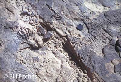
The Early Silurian Taini Ravine Sea continued to rise until all the land of North Africa was covered and therefore water could circulate and was better oxygenated. We know that the sea was warm and shallow, as seen by fossil impressions of Skolithos in the sandstones together with its burrows, erosion channels, shelly beds, current ripples and Thalassinoid worm burrows. Muds that were deposited with lower organic content gave rise to grey or ‘Lean Shales’.
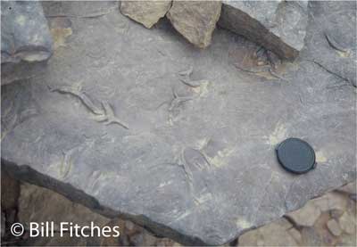
Thelassenoides burrows.
The organic-rich shales/muds had to be buried by 2000m+ sediment cover before they would start to generate oil/gas from the algal material in them. By the pressure thus generated, oil and gas formed from the organic materials. Next the land was tilted and faulted, causing the oils to migrate.
Summation: make a reservoir (palaeovalley), deposit the source rocks (porous sandstones), cover with organic muds, and seal them, - mudstones make a good seal - then squash them, to convert algae and other ocean organisms to oil and gas.
The rest of Bills’ talk was an elaboration of the similar scenario in Wales.
Write up by Bonni Sinclair.
An in-depth paper on this topic is held in the U3A geology library:
Lower Silurian ‘hot shales’ in North Africa and Arabia: regional distribution and depositional model.
S. Lűning, J. Craig, D. K. Loydell, P. Štorch, B. Fitches