Midsummer Hill walk
The U3A geology group walked the Midsummer Hill and the Gullet Quarry area on Tuesday 15 September 2009, led by John Payne from the Earth Heritage Trust .
Click here for:
o Map
o Visit report by Elizabeth Stanley
If you want to repeat the majority of our walk, you will need the Malvern Hills (2) Earth Heritage Trust trail guide. This can be purchased from Herefordshire and Worcestershire Earth Heritage Trust; Geological Records Centre; University of Worcester; Henwick Grove; Worcester WR2 6AJ (01905 855184), or from the Malvern Tourist Information Centre. Cost around £2.
The walk started at Hollybush car park, grid ref SO758369.
Don’t forget to click down into web links for additional information. These are generally accessed via highlighted words on the titles of the pictures.
Map
A map of the route taken is included below, including a simplified key to the geology
.
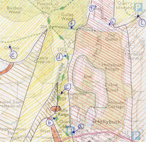
The route and simplified geology.
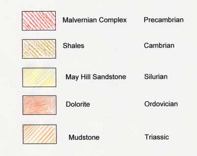
Geology key
Visit report by Elizabeth Stanley
We met at Hollybush car park (point (a) on the map), and John Payne introduced our location on the uptilted slab of the Malvern Hills where a zone of transverse faulting has resulted in a gap through the watershed. We set off northwards, more or less following the Malvern Hills (2) Geology and Landscape trail of the Earth Heritage Trust.
We walked up the track on the west side of Midsummer Hill which follows a belt of Hollybush Sandstone (point (c) on the map). We looked down on lower ground around Bronsil Castle, underlain by Cambrian shales. A nearby ridge and other 'tumps' below us are formed by outcrops of Ordovician igneous rock. Further along the track we looked at the breaks of slope, and John explained how they provide the kind of information that has contributed to geological mapping.
At one point large blocks of Malvern stone have been placed to exclude vehicles. On them we reckoned that we found striations and polishing that could be evidence of rock movements due to faulting (point (d) on the map).
Soon we turned west onto the track leading to the obelisk. Now we were on early Silurian May Hill sandstone, and we could easily pick up squared pieces of this yellowish rock with occasional fossils. This sandstone forms the anticlinal ridge which runs west and then South West from the line of the Malvern Hills but is geologically quite distinct. The obelisk itself is built of Jurassic limestone from the Cotswolds. We could pick out the ooliths which form this granular rock, and fossils such as crinoid ossicles (point (e) on the map).
Looking at the view to the south west, John pointed out the valley of the Glynch Brook which runs through Eastnor and eventually joins the Leadon and the Severn. Half a million years ago this was part of a larger river flowing south which was then blocked by ice so that its upper section was reversed to form Cradley Brook. Beyond the valley were the lines of the Ledbury and Woolhope hills.
We reversed our steps, crossed the main line of the hills and continued eastward down the Gullet Pass. In a small quarry to the right of the track an early Cambrian beach is exposed. There are small pebbles in the hard quartzite sandstone, and some marine fossils (point (f) on the map).
Further down the track, we turned off to the left and followed the path above the quarry up to the famous contact between the Malvern rocks and the steeply dipping beds of May Hill Sandstone. John mentioned the long-running controversy as to whether this contact is an unconformity or a fault. He showed us the remaining fragment of Silurian beach, with large rounded pebbles, and the striking ripple marks on the broadest bed of sandstone. The diorite of the upper quarry face formed an impressive backdrop (point (g) on the map).
We returned to the track and descended to the wall that closes off the bottom of the quarry. We looked at the Malvern stones embedded in the top of the wall, and many of us regretted our inadequate identification skills! (point (h) on the map).
Our final stop was on Castlemorton Common, where we looked out over the comparatively flat Severn Valley. John talked about the long history of the Malvern fault, along which the hills had been thrust up and later the land to the east had dropped by 3000m., to be filled with Triassic and Jurassic sedimentary rocks. More recently earth movements in southern England, Ice Age conditions and changes in the drainage over a wide area have all affected this landscape(point (i) on the map).
We had spent the morning learning a lot of interesting and wide-ranging geology, thanks to John's skilled guidance and explanations pitched at an appropriate level for our group. We were certainly ready for lunch at the Farmers Arms, where the good food - and perhaps the slow service! - gave us a chance to chat and make new friends.
The walk itself
Geological background of the Malvern Hills
At the start, John gave us a short talk to set the scene for the field trip.
The rocks of the Malvern Hills are amongst the oldest in our island. They were formed during volcanic activity about 670 million years ago, deep underground. They were part of a magma chamber, where molten rock makes itself a large cavity deep underground where it very slowly solidifies. This slow solidification produces large crystal sizes in the rock that is formed.
The making of the Malvern Hills, as actual hills, happened a lot later than the 670 million years ago. After these rocks were originally formed, the rocks on top of them eroded away exposing some sort of hills, but not the Malvern Hills we see today. Then, 300 million years ago, as the result of a continental collision, the rocks as we see them today were thrust up. This formed a thin plate, maybe 300-400 metres at the thickest point, thrust up at an angle of about 30 degrees out of the earth. The fault which created this thrusting continued underground for about 12-14 kilometres depth at least, extending down under Worcester. This slab of rock has remained upstanding, well above the surrounding landscape. It is very hard, not being easily eroded or dissolved in water. Many other rocks have been laid down above and around. Sometimes it has been covered by the sea, causing limestone and sandstones to be deposited.
On the West side of the hills towards Herefordshire we see limestones, mudstones and sandstone of different ages. These rocks are typically 400 million years old (Silurian). On the East side of the hills we see the flat Severn Valley. Here we have younger rocks. typically 250 million years old (Triassic). All the rocks going out to the South East of England tend to get progressively younger.
John then spoke about our current location at Hollybush pass. There are quite a few gaps like this in the hills, for example Wyche Cutting, Wynds Point and Whiteleaved Oak. All of these were due to faults or breaks in the rock. The thrusting of the rock didn’t occur as a continuous slab; there were the occasional breaks. Around these faults in the rock there would have been a grinding action, breaking up the rock and creating a place of weakness. At these points the rock would have been more easily eroded. So, after millions of years gaps would appear and create the passes we see today.
Igneous Intrusion
We walked North along the Worcestershire Way path, crossing the cattle grid, and stopping at a shed in an adjacent field (point (b) on the map).
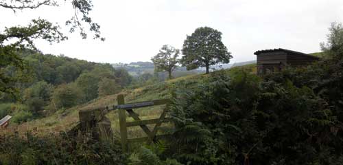
We took in the view, looking west towards Herefordshire. John said that the rocks underneath us were sedimentary of Cambrian and Ordovician age. These old rocks underlie the whole of Herefordshire, but are exposed in this area only.
These soft sedimentary rocks are shales and sandstones. The bump just in front of us with the tree on top of it is actually a piece of volcanic rock. In Ordovician times a major continental collision occurred; this merged Scotland with England and Wales. The main impact of this collision was felt outside of this area, but there were inputs of molten rock into the existing rocks. This lump in front of us was one of them, and is called an igneous intrusion. It was originally underground, and over time the softer rocks around it have been eroded away and it now stands proud. In this Whiteleaved Oak valley there are around a dozen exposures of similar volcanic rocks.
The view West
We continued North along the Worcestershire Way for half a kilometre (point (c) on the map).
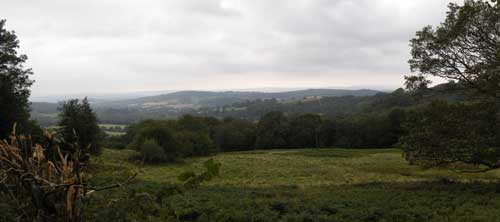
We stopped and examined the view. We were standing on Hollybush Sandstone (530 million years old, Cambrian in age). The low ground in front of us is comprised of Cambrian and Ordovician rocks, both shales and sandstones. This area is bounded by a ridge, curved round with the Obelisk on top of it. It is just possible to see the Obelisk through the trees on the right. The hill around the Obelisk is comprised of Silurian May Hill Sandstone. This sandstone is harder than the surrounding shales, so remains upstanding.
All the rocks from the Obelisk to British Camp slope slightly to the north, and tend to be arched in an anticline. One may think of it as being like an archway cut off horizontally.
Looking right to left it as possible to see where the hard sandstone turns into the softer shales. There is a change of slope and the tree line begins.
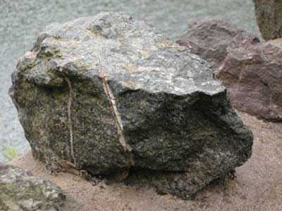
We continued North to point (d) on the map. We viewed the boulders by the gate, which were Precambrian granite. One had a greenish colour caused by epidote, a common mineral in rocks that have been buried at high temperatures and pressure.
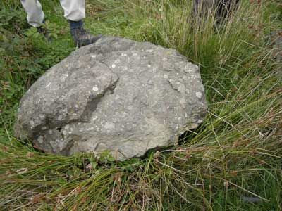
Epidote
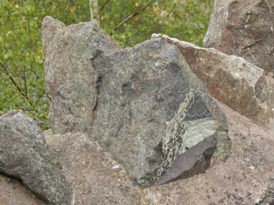
Other boulders had scratches called striations. These are caused by the abrasion of rock faces against each other. This indicates there has been ground movement in the past.
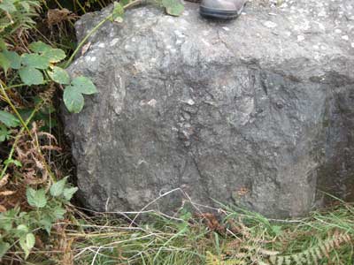
Striations
The Obelisk
We continued North along the Worcestershire Way, then taking the path to the West to the Obelisk (point (e) on the map). We saw some good exposures of May Hill Sandstone around the path leading up to the Obelisk.
The Obelisk itself was erected in 1812, and comprises two sections. The base is Silurian limestone, sourced locally. The main section is Jurassic oolitic limestone from the Cotswolds. In the base we found ossicle fossils. These were part of the stem of Crinoids, commonly known as “sea lilies”. This is evidence that the limestone was deposited in a shallow, tropical sea. It is interesting to compare the round “polo mint” shaped ossicle to the star shaped ones we found in Bredon Hill.
Exposure of May Hill Sandstone
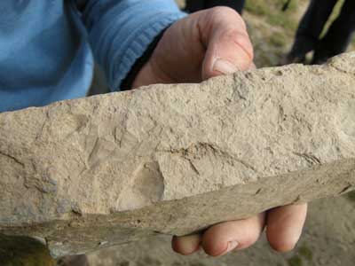
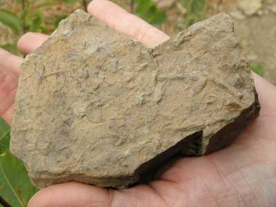
Tabular slab of May Hill Sandstone, with fossils
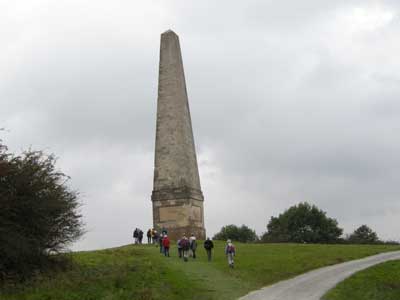
The group approach the Obelisk
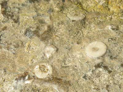
Ossicles in the Silurian limestone on base of the Obelisk
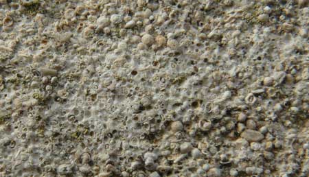
Jurassic oolitic limestone in the Obelisk
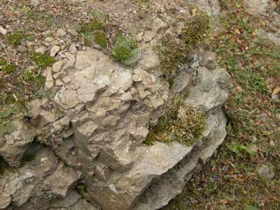
The Cambrian beach
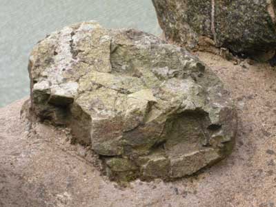
We now headed East towards Gullet Quarry (point (f) on the map). In the pass between the hills, on the Northern side, John showed us a small quarry known as Gullet Pass Quarry. The rocks in this quarry are of Cambrian age. They were laid down in a zone between the land and the sea. The remains of a beach are visible. This contains marine fossils and rounded pebbles from Malvernian rocks. The pebbles are interleaved with layers of very hard sandstone known as quartzite. The quartzite here is not a true metamorphic rock, rather it is just a sandstone which is cemented by silica possibly dissolved from the sand grains and then precipitated.
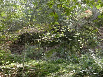
Gullet Pass Quarry
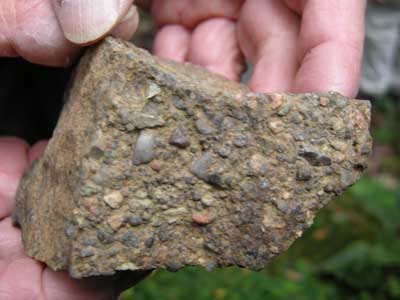
Cambrian beach pebbles on quartzite
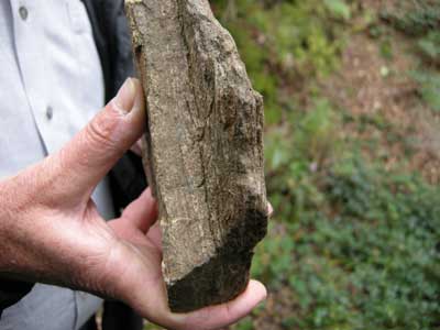
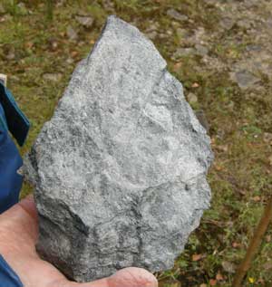
A piece of Malvernian gneiss
Gullet Quarry – The Silurian Beach
We continued East to Gullet Quarry.
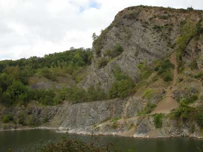
Gullet Quarry
We took a path to the North West corner of the Quarry to see the famous unconformity, known as the “Silurian Beach” (point (g) on the map). Here we examined the junction between deeply dipping Silurian May Hill Sandstone and the Malvernian Precambrian rocks. Between the Silurian sandstone and the Malvernian there is an area of conglomerate, with large rocks and pebbles of Malvernian age. This area represents an actual beach by the Silurian sea some 440 million years ago.
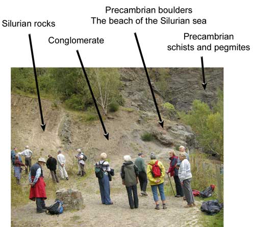
The “Silurian beach” at Gullet quarry
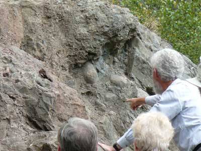
A detailed examination of the third arrow from the left. John points out to us the Precambrian boulders which were at the base of the remains of the Silurian beach. The rocks have been uplifted and tilted by nearly 90 degrees. The rocks to the right of the boulders are Precambrian schists and would have been the floor of the beach. To the left of the boulders we have conglomerate which constitutes the actual beach. Further left, out of shot in this picture, is Silurian May Hill Sandstone. This was laid down after the beach was formed.
There are many fossils in the fine-grained sandstones and siltstones of the Silurian rocks. The picture below shows casts of animals walking along the shore. There are no shells to be seen, only casts. This is because percolated water has decalcified them, dissolving out the hard parts, leaving only the casts.
Precambrian mica schist
Gullet Quarry – The quarry wall
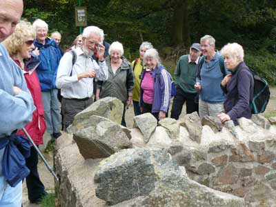
We continued around the side of the quarry and examined the Precambrian rocks in the wall (point (h) on the map). John told us what a number of them were.
Hollybush Roughs
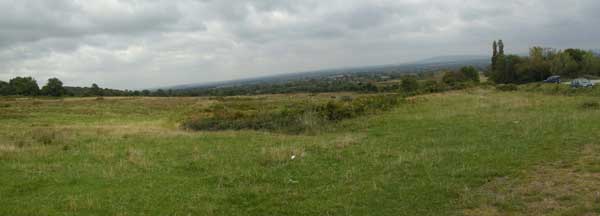
The walk ended by continuing East and viewing the scenery (point (i) on the map). The flat Severn Plain that greets us, with Bredon Hill beyond, is very different to the Silurian and Precambrian we had just left. At this point we were walking along the East Malvern Fault line. East - West tectonic forces acting on this fault caused huge earth movements, forcing up the ground to the West by some 3 km. This exposed the rocks which would otherwise have remained buried below the surface. The East Malvern Fault, and a similar fault to the East, created a rift valley which was subsequently filled with the relatively young Triassic deposits we see today.