Walk over Ankerdine Hill to Knightwick
The U3A geology group walked over Ankerdine Hill to Knightwick on the 14 July, led by Rosemary and Colin Fretwell.
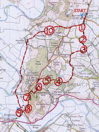
The walk was circular, starting and finishing at the Admiral Rodney pub in Berrow Green (Grid ref Explores 204, 748583). It follows a part of the Geopark way, Section 8, pages 69 - 72. The Geopark Way book produced by the local Earth Heritage Trust. You can purchase it from Herefordshire and Worcestershire Earth Heritage Trust; Geological Records Centre; University of Worcester; Henwick Grove; Worcester WR2 6AJ (01905 855184).
Click here for:
Map
Description of the walk by Elizabeth Staley.
Numbers refer to the map above and Rosemary’s geological notes below.
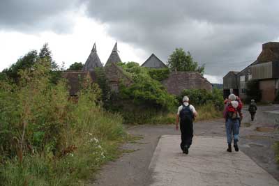
On 14th July, 19 of us met at the Admiral Rodney pub in Berrow Green. We set off, led by Rosemary Fretwell and back-marked by Colin. We headed roughly south-west and soon joined the route of the Geopark Way (section 8). Where we left the lane (stop 1 on the map) and could gather round Rosemary in the first field, she explained that we were walking over Triassic mudstones and sandstones. She described the hot dry conditions on the supercontinent of Pangea, and the development of plants and small animals on the land. This set the pattern for the walk: at each new feature and view Rosemary gave us varied and interesting information about the relevant period. Her notes are below.
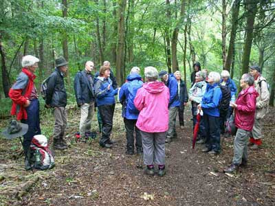
We descended into the next field (stop 2) where we looked at the soil colour, and learned about the related conditions and chemistry. At stop 3 we got a rather misty view of the Malvern Hills and heard about their origin as an island-arc. At stops 4 and 5, as we climbed up through Nipple Wood, Rosemary explained the faulting that brought us onto the Silurian rocks, formed in a shallow warm sea. We reached the top of Ankerdine Hill (stop 6), and heard about the bentonite which is derived from volcanic ash and occurs in thin layers between the beds of Silurian limestone. It has various industrial uses. Its significance for the landscape is that, being soft and slippery, it leads to landslips and resulting hummocky ground.
We zigzagged down the hill until we joined the B4197 at a small quarry (stop 7) formerly used for building and road material. Two or three hundred yards down the road we came to the redundant Knightwick church (stop 8), built of local sandstone and Cotswold limestone. Just beyond the Talbot Hotel we stood on the footbridge over the River Teme (stop 9), where Rosemary explained the river’s history since the Ice Age, and stretched our imagination of the scale of geological time.
The last stage of the walk took us north along the Teme’s flood plain as far as Horsham Farm. From here we climbed up the valley side, past the spring line (stop 10) and back onto much older rocks. Now we were close to our starting point and to a welcome lunch at the Admiral Rodney.
Rosemary’s understanding and commentary was much appreciated. Most of our walks and trips take a close look at details of the local rocks and structures, but this was different, with a broader sweep of geological history and vivid descriptions of conditions during the relevant periods.
Rosemary Fretwell’s notes on the Geology
We will make ten stops on the way. These are located and numbered on the accompanying map.
1st stop – by hedge gap
We are walking over Triassic rocks which are 230 million years old.
During the Triassic period between 250 and 200 million years ago, almost all the Earth’s land mass was concentrated into a single supercontinent called Pangaea, meaning ‘all the land’. Most of the world was sea.
All the deep-ocean sediments laid down during the Triassic have been subducted, so what we have remaining is only the remnants of the huge continent of Pangaea.
The climate was mostly hot and dry. Typically this led to the laying down of sandstones and evaporates. It is believed that the earth was completely ice-free at this time. Because of the size of the single continent, the summers would have been very hot and the winters very cold.
The Triassic period began (and ended) with a major extinction event (probably caused by some sort of volcanic activity). So there were many niches left open at the beginning of this period.
The Permian-Triassic extinction devastated terrestrial life. Biodiversity rebounded with the influx of disaster taxa, however these were short lived. Diverse communities with complex tropic structures took 30 million years to re-establish.
Seed-bearing plants from the group now represented by our conifers came to dominate the land. Flowering plants developed later.
On land we had amphibians including the first frogs, lizards which were hardly dinosaurs yet, primitive crocodiles and eventually the first turtles. But think small!
Another extinction at the end of the Triassic allowed the dinosaurs to expand into many niches that had become unoccupied. Dinosaurs became increasingly dominant, abundant and diverse, and remained that way for the next 150 million years. The true "Age of Dinosaurs" is the Jurassic and Cretaceous, rather than the Triassic.
We shall be walking over a mixture of red mudstone, probably laid down during monsoon-like storms, and bands of sandstone. The sandstones have formed caps to the subdued hills, and the mudstones have eroded to form the lower land.
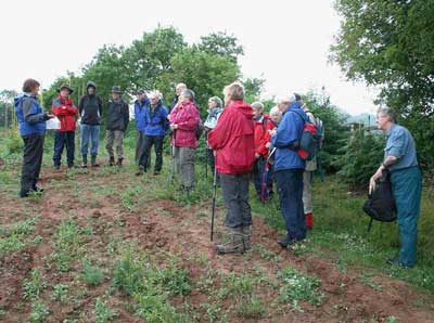
Learning about Triassic Red Beds (stop 1)
2nd stop – gate by market-garden field
Red bed are strata of reddish-coloured rocks such as sandstone, siltstone or shale that were deposited in hot climates under oxidising conditions. The red colour comes from iron oxide in their mineral structure. The reddening of the sediment by the dehydration of brown or drab coloured ferric hydroxides. 2FeOOH (goethite) (brown) → Fe2O3 (hematite) (red) +H2O (which evaporated in the heat).
It was hot – desert conditions. There was oxygen in the atmosphere, so green plants had evolved. In fact it was likely that the atmosphere was a lot more oxygen-rich than it is today because terrestrial plants were prolific, having evolved ahead of terrestrial animals all of which would have been very small at this time.
The conditions were not conducive to the preservation of fossils, so few are found in red beds. But oil can be found in red beds, particularly those of the United States, so it is an important rock-type.
3rd stop – where we turn off the lane and get a good view of the Malvern Hills
The Malvern Hills are an anomaly, the remnants of a Pre-Cambrian island-arc which pushed their way up through layer upon layer of much younger rocks until they are exposed at the surface. They are crystalline igneous rocks which developed from magma deep within the earth’s crust.
Originally they would have risen to the surface at a constructive plate margin such as the present-day mid-Atlantic Ridge. Solidified into ocean crust, a few million years later they would have collided with oceanic crust coming the other way from another constructive plate margin. Think of a head-on car crash in slow motion! One of the plates would have been marginally stronger than the other, so the weaker one would have been subducted. The friction of the two plates rubbing together would have caused explosive volcanoes, and an island-arc would have formed. As island-arcs grow in size they eventually become continents. A good example of a present-day island-arc is the South Sandwich Islands in the Southern Ocean. The Malvern Hills probably remained an island-arc as it got buried beneath younger sediments over millions of years.
The Malvern Hills were formed 680 million years ago, somewhat earlier than the 230 million year old rocks we are walking over now. The nearest rocks of that age, apart from Malvern, are found in northern Scotland – England and Wales are far far younger!
The Malvern Hills are on a south-north axis. They stop suddenly at North Hill, but lesser hills continue northwards on the same axis with the boundary of 430 million year old Silurian rocks to the West and 230 million year old Triassic rocks to the East. If you stand on the ridge of the Malvern Hills, you will notice that the land to the East is at a much lower elevation than the land to the West. This is not only because the River Severn wore away it’s valley in recent times (geologically speaking). It is mainly because the older Silurian rocks were pushed upwards whenever the earthquakes which caused that fault line occurred. Any of the younger Permian and Triassic rocks covering the Silurian at the time was probably completely eroded away due to its high elevation.
There was probably a series of enormous earthquakes deep within the crust at some time, and the island-arc, which is now the Malvern Hills, thrust itself up through the fault boundary because it was the weakest point. (That’s my theory, anyway!) Exposed to the atmosphere (oxygen is a fairly active gas) and weather, it eroded to the line of hills we know today.
Shortly we shall be crossing the boundary from the 230 million year old Triassic rocks to the 430 million year old Silurian rocks. This boundary is called the Malvern Axis because it is the same fault line that the Malvern Hills pushed through a few miles further south.
4th stop – as we enter the wood
We are about to step over a geological boundary – from 250 million year old Triassic rocks to 440 million year old Silurian rocks. You would expect the older rocks to be lower because they were laid 200 million years earlier, therefore should be underneath. But there is a major fault line from north to south, a continuation of the Malvern axis, the same fault line that pushed the Malvern Hills high above the surrounding strata.
The climate in Silurian times was wet and warm. There was ice at the poles, but not much. If we had been standing on this spot 430 million years ago we would have been standing on the margin of a warm shallow sea. There would have been some oxygen in the atmosphere, but also an awful lot of carbon dioxide leading to a major greenhouse effect. Broken shells in Silurian strata provide evidence that the weather was dominated by violent storms.
Life was a lot more primitive than the later Triassic, and would have been mostly in the sea. Coral reefs made their first appearance during the Silurian age, also boney fish with movable jaws, sea scorpions, leeches, brachiopods, bryozoa, molluscs, and trilobites. Some of these animals are still with us today!
Shallow-rooted plants were invading the land, especially mosses which formed forests along lakes and streams. There were also primitive vascular plants, i.e. plants with tissues that carry food. There was no differentiation in the roots stems or leaves of these plants yet, they would have reproduced by spores, breathed through stomata on every surface, and every tissue that was exposed to light would photosynthesize. During this period, the oxygen content of our atmosphere increased dramatically, and the carbon dioxide content decreased accordingly. There were no trees as yet, and flowers didn’t evolve until many hundreds of million of years later.
Terrestrial animals only existed in the form micro-organisms and tiny invertebrates such as microscopic spiders and millipedes. Simple food webs were in place by the end of Silurian times.
In detail, the younger Triassic rock we are now walking on is the impervious Mercia Mudstone – hence water, streams and a muddy path. The older Silurian rock we are about to step on to is the highly permeable Bromsgrove Sandstone which here has been raised above the mudstone by a fault. Hence we climb a hill and the path becomes drier.
Think of the mudstone as a sheet of polythene. Think of the sandstone as a sponge. If you pour water on the sponge it will soak in and sink until it reaches the polythene. There it will run out in rivulets because it has hit a waterproof layer. That is the spring. Below us near the stream there is a well, but it is difficult to locate and reach through the summer vegetation.
Learning about Silurian seas, Ankerdine Hill (stop 4)
5th stop – halfway up the hill
Think back to that Silurian Sea. It was warm and shallow, the weather was inclined to be stormy. Over time a variety of sandstones, limestones, mudstones, shales and bentonites (more about them later) were laid down and then all mixed up. (Christmas pudding mix analogy) That is what makes up Ankerdine Hill. For some reason they glued together a bit better at this spot, and didn’t erode so much. They stayed put.
6th stop at the picnic site
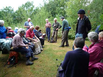
Rest at the top of Ankerdine Hill (stop 6)
Bentonite is a clay formed from very fine volcanic ash. It never solidifies into hard rock, but remains soft and slippery. It is this property which makes it a valuable mineral for use in the drilling industry (it forms ‘mudcake’), cement, adhesives, ceramics and even cat litter. Fuller’s earth is a finely ground bentonite. Bentonite clay is used in pyrotechnics, etc, etc.
Bentonite also has the interesting property of adsorbing relatively large amounts of protein molecules from aqueous solutions. It is therefore uniquely useful in the process of winemaking, where it is used to remove excessive amounts of protein from white wines. It also has the incidental use of inducing more rapid clarification of both red and white wines.
Bentonite is also used as a base for many dermatologic formulas, and has been prescribed as a bulk laxative!
But here on Ankerdine Hill there is not much of it, and it is not very pure. It has led to land slippage. Layers of bentonite, each a few centimeters thick, are interbedded with limestones and shales. Since it is soft and slippery, they tend to slide down the southern slopes of Ankerdine Hill. Now, apparently, only detected by the slightly hummocky ground, the trees younger than those of surrounding woods, and relatively sparse undergrowth. (See if you can see these signs as we go down! It’s grown up a bit since the Geopark Way book was written!)
7th stop car park at bottom of zigzag path
Ankerdine Common used to be quarried on a small scale to provide road and building materials. Stone from here was used to build Knightwick Church and several cottages in the area.
When we get to the church, we hope to show you a number of fossils in the stone – mostly shelly sea creatures.
8th stop Knightwick Church
The church is built of fine-grained grey sandstone in which we have found some fossils. The door and window frames are made of a stone imported all the way from the Cotswolds – a yellow oolitic Jurassic limestone.
The gate pillars are of grey siltstone in which you can see small-scale cross bedding.
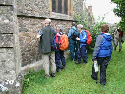
Looking for fossils, Knightwick Church (stop 8)
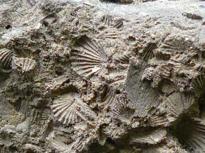
Brachiopod fossils at Knightwick Church (stop 8)
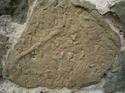
Trace fossils at Knightwick Church (stop 8)
9th stop on the footbridge over the Teme
Geologically speaking, the River Teme was five minutes ago!
The last ice age, 20,000 years ago, was even younger.
Just to show you the power of the meltwater when that ice age came to an end – it blew a hole in the line of hills that make up the Malvern Axis, and the River Teme gushed through it because it was an easier route. There it found the Severn Basin, and nowadays joins up with the River Severn just south of Worcester.
We are now going to walk along the Teme river valley, the youngest rocks you will walk on today. They are probably less than one million years old.
The footbridge over the Teme (stop 9)
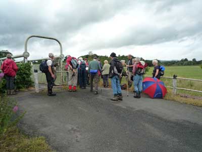
10th stop on ‘log’ bridge after bridge stile (up the side valley above Horsham Farm)
Point out the spring line, where the water seeps out from under the Triassic Red Beds. We are back on ancient rocks.
Ankerdine Farm, Knightwick (stop 10)