Ivy Scar Rock walk
The U3A geology group walked up Ivy Scar Rock in the North Malvern area on the 23 June, led by Richard Edwards.
Click here for:
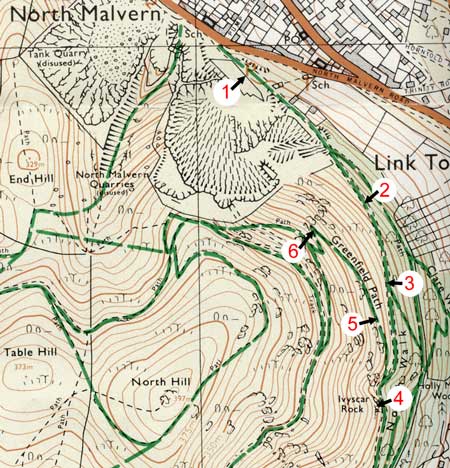
Map
Report on the walk
The following report is based on Richard Edwards discussion with to the group. Directions are included in italics. Additional geological information is included as hyperlinks.
We assembled at the Tank Quarry car park, grid position 772469 and point 1 in the map.
The evening started off by focusing on the structure of the area. Two units, the Worcester Basin and the Malvern Hills, are separated by the major structure, the East Malvern Fault. This fault is of crucial importance in understanding the geology of our area. The East Malvern Fault extends from the Cheshire Basin to the Bristol Channel where it is covered over by younger sediments and it may extend much farther than that. It probably represents a major junction between 2 small micro-continents. That junction has been an area of dislocation throughout the last 500 million years. It is expressed in 2 ways in our part of the world. Firstly as a thrust fault i.e. the rock has been thrust up over another rock; this can be clearly seen in the Herefordshire Beacon area. Secondly, in the the folds of the Silurian rocks to the West of the Malverns.
Tens of millions of years later, the stress regime changed its character and instead of pushing and thrusting, the movement starts to be an extensional movement. The rocks have been pulled apart into a rift structure and we see the start of the formation of the Worcester Basin. If we drill down we need to go down about 2 km before we find the Malvern Complex again on eastern side of the fault. So, at point 1 on the map in the car park, here we are standing on rocks of the Triassic age. A few steps along the path we cross the fault and we are on the rocks of the Malvernian.
The evening was split into three parts: first, igneous rocks, the main component; second, the fault itself; third, the wider geological context as seen looking east across the Severn Valley. And of course, the Ivy Scar Rocks a group of igneous rocks which are rather special.
We were shown a rock classification diagram (below). The rock types we saw on this field trip were diorites, micro-diorites and granites.
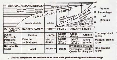
Rock classification diagram
Diorite is a coarse-grained rock made up of plagioclase and hornblende. Micro-diorite (to be seen in Ivy Scar) has the same mineralogy but is more finely grained. Granite is made up of quartz, alkali feldspar and plagioclase feldspar. So the distinction between these types of rock is based upon each one’s type of plagioclases, the presence or absence of quartz and the type of ferro-magnesian mineral. (Note the definition: plagioclase = any form of a rock-forming series of triclinic feldspars, consisting of mixtures of sodium and calcium aluminium silicates).
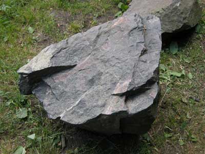
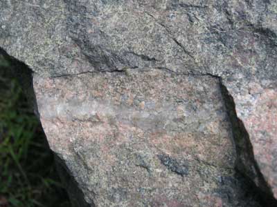
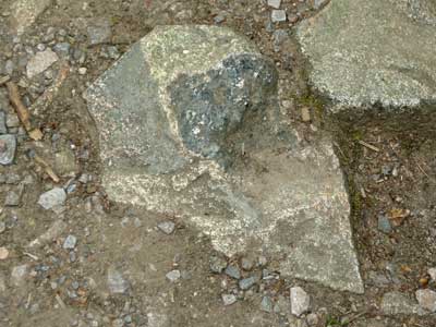
The rock at the car park
We started the field trip by at a very interesting rock next to the car park itself, pictured above. Its original mineralogy is a bit obscured, there is quite a coarse grained unit and quite altered. Note the dark ferro-magnesian minerals. It is in the range of a diorite - and is quite dark. The rock has been intruded as a molten magma and then cooled down. After it has cooled it has fractured and then the fractures have been filled by little veins of granite.
Granite filling fracture in diorite.
In the view above the granite is penetrating along quite small fractures. In all different orientations the granite has found a way through. During a final phase some of the fractures must have opened up late. There is a little quartz vein amongst the granite veins (below).
Quartz veining amongst the granite
There is also the mineral epidote which is cooling the fracture. It is green in colour – calcium silicate.
Epidote – which is coating on fracture
It is possible to find epidote as an accessory mineral, but it mainly occurs in narrow veins. It is difficult to be exact about the timing, but basically there is just a narrow fracture open just long enough for a hot fluid to migrate up it. It is very nicely expressed in the boulder below.
We walked a few tens of metres South West, leaving the car park path and arriving at the base of the quarry.
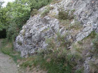
East Malvern Fault
The fault is very well exposed in the picture below. Basically, the exposure shows the fault dipping down at an angle of 60˚. The rock is a fault breccia, made up of a series of broken fragments of igneous rocks - diorite and other rocks within the Malvern Complex. These are cemented together by fragments of a fine grained sandy nature. This, therefore, is a classic fault breccia.
The movement on this fault on the Eastern side of the system has been such that the hanging wall is displaced 2 km down. Yet the extent of the fault zone seems to extend no more than a metre of so. An interesting feature is this series of lines – slickensides – which are usually taken to be an indication of the direction of fault movement. Here they are vertical which is helpful since that is the same direction that the fault displays. Not too much importance can be placed on slickensides in the Malvern area because there has been so much movement in the Malverns. However, here it is nice to see them right up against the fault fracture.
Ten yards further along is another and much better exposure of the fault – but we did not see it on this walk.
We progressed slowly along the path towards our main objective – the Ivy Scar Rock. Along the way there were several small rocks in the path that we examined.
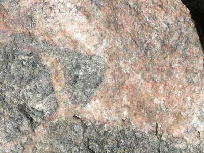
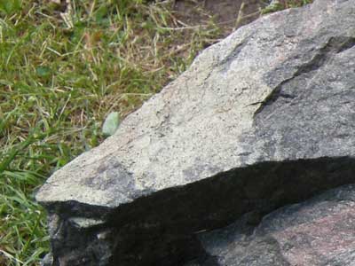
First rock on the path to Ivy Scar Rock (point 2 on the map)
The cream coloured crystals here are plagioclases - probably 50% calcium and 50% sodium. The dark coloured sections are ferro-magnesian minerals, probably hornblende. The hornblende is probably altered to chlorite. Looking at this under a microscope in thin section there would probably be clear twinning of the plagioclase crystals and some cores of hornblende. These rocks have been metamorphosed at least twice and the metamorphism causes mineralogy changes. In the Malvern area, metamorphism sometimes causes a sort of banding so there is physical transformation as well as mineralogical change.
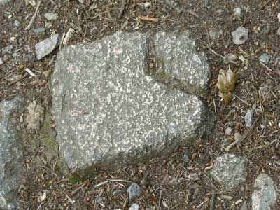
Second rock on the path to Ivy Scar Rock (point 3 on the map)
This rock is an example of a xenolith. The dark coloured diorite is surrounded by younger granite.
Again, this rock is a mix of cream coloured plagioclases and the darker ferro-magnesian minerals. Some of the plagioclase is starting to invade the darker xenolith. If they were floating about in a magma at 1000˚ centigrade this type of interaction would be expected. It looks as if the plagioclases are starting to be converted. There is a diffuse sort of boundary, and the xenolith has been eaten away round the edges. It is clear that the magma has cooled before the intrusion has been totally assimilated.
We arrived at Ivy Scar Rock, point 4 on the map.
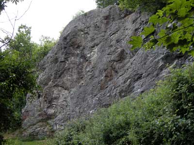
Ivy Scar Rock
Ivy Scar rock is an igneous intrusion. Its mineralogy is very similar to what we saw on the way up, based on diorite, but the grain size is much finer.
Fine grain size of the Ivy Scar Rock
The conclusion is that this intrusion was at a shallower level than the diorite we saw on the way up. The main body of the Malvern Complex, formed 670 million years ago, was very deep in the Earth’s crust – about 35 kms down. Ivy Scar is probably much shallower, perhaps 2 or 3 kms from the surface. It therefore cooled at a much faster rate and so has a smaller grain size.
On the 10,000 geological map Ivy Scar is part of a series of small blobs – not very helpful. A PhD thesis carried out in the 1930/40s shows Ivy Scar as a more continuous unit, but an intrusion of unknown orientation.
We considered the age of the Ivy Scar Rock. We only know of the ages of rocks by radio-active determination. There are only half a dozen or so of the rocks of the Malverns where this has been undertaken, none of them being micro-diorite . So we can only use a series of geological guesses to tell us what age Ivy Scar is. For example we can guess the relationships; we know that these rocks are later than the pegmatites. Good examples of pegmatites can be seen at Dingle Quarry (right opposite the Brewers Arms). The pegmatites have been dated at 600 million years. So Ivy Scar is perhaps somewhere between 550-600 million years and therefore much younger than the Malvern Complex.
Is Ivy Scar part of the same magmatic system as the Malvern Complex?. The chemistry, both the major and the minor chemistry, suggests that the rocks of Ivy Scar are of a different range and have a higher iron content than the Malvernian rocks. So it is thought that this is an entirely different magma at depth.
Finally we discussed the layering of Ivy Scar. It looks like separate lava units, especially on the picture above where there is a sort of waving around of the layers. Our guide was of the opinion that these were essentially fractures, almost certainly associated with the East Malvern Fault. Each fracture is associated with a thrusting movement. Looking closely there are two different orientations showing two different types of fracture. One is dipping away at an angle of about 30, as expected, the other near vertical.
We headed towards the viewpoint, stopping at an interesting rock on the way (point 5 on the map).
Rock on path between Ivy Scar Rock and the viewpoint
We discussed the layering of this rock. Again, there are two different orientations. One is no doubt structural, the other may be compositional. It is possible that there was some sort of disturbance of compositional layering – disturbance of the original layering within the micro-diorite which has been rotated by some sort of violent current within the magma chamber. If so, this is evidence of primary layering within the micro-diorite and these fractures are later, probably linked to the East Malvern Fault. The only way to resolve this is by getting a couple of samples, looking at them in thin section and seeing whether that reflects structural or composition layering.
Our final stop is the viewpoint, point 6 on the map.
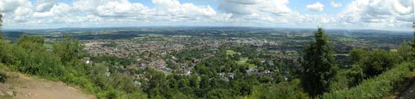
Viewpoint
We discussed the vista above, and how the view had altered over geological time.
The British Isles emerged out of the sea about 65 million years ago, at the end of the Cretaceous period. Prior to that emergence it was under water for about 200 million years. When the land emerged out of the sea there would have been a huge thickness of Jurassic and Cretaceous marine sediments. There would have probably been between 1 and 2 km of sediments. During the Anglian, and more recent ice ages, there were probably 500m of ice on top of that as well. That huge thickness of marine sediments has been eroded away to produces the landscape above. What we see is a Triassic landscape, a featureless desert then, but essentially the same Triassic landscape, now revealed to us.
It was suggested that we visit Aust which has a good exposure of the first sedimentary layers of marine origin, dated about 200 million years ago.
Looking at the view above, there are a series of smaller hills in a low flatish valley. Underneath the Worcester Basin are sedimentary rocks. The main Malvern town is on rocks of Triassic age, 270 million year old and 2 km thick. The Malvern Fault pulled apart to form a graben. This is one side of the fault and the other side is roughly parallel to it through Inkberrow. It is similar to the Rift Valley in Africa, but in this case, filled up with a sediment of Triassic age
Finally we discussed the other visible hills.
Inliers are basically older rocks protruding through a younger cover. For instance, the Lickey Hills to the North East here are originally quartzites, probably the hardest of all rocks, resistant to weathering. They are Ordovician/Lower Palaeozoic, older than these Triassic rocks. They were thought of as being Cambrian until relatively recently but are now seen as a bit younger.
Bredon Hill, to the South East, is an Outlier. It is really part of the Cotswolds. When a scarp is being eroded and rocks are retreating, some seem to get left behind. Bredon Hill is the younger Jurassic rock on top of older Triassic rock i.e. younger on older = an outlier .
It is possible to see the southerly dip of 5 to 10˚of the scarp slope which is gently folded.
The hills of the middle ground (Dripshill Wood)
The line of lower wooded hills half-way to Bredon are Triassic in age, but more resistant to weathering than their surroundings. Whereas the Triassic rocks are relatively soft mudstones and siltstones, Dripshill Wood is a Triassic sandstone more resistant to weathering.
Abberley is to the North, Silurian sedimentary hills which were folded up during the compression and thrusting stage of the Variscan orogeny.