Knapp and Papermill
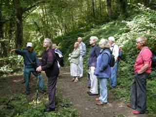
On 1 September 2010 members of the Malvern U3A geology group met to undertake a field trip to the Knapp and Papermill led by Jim Handley.
Click here for:
- Report on the walk
- Pictures of the walk
- Extracts from Edwin Lees book Pictures of Nature of 1856
- Ice Age draining of the area
Report on the walk, and the geology of the area
Objectives –
- To look at the geological development of the area.
- To consider the impact of glaciation on the general drainage pattern and on the Leigh Brook in particular.
Geological history
Using a display board produced for Worcestershire Wildlife Trust about 20 years ago (see below), we were able to see the main stages in the geological history of the area:
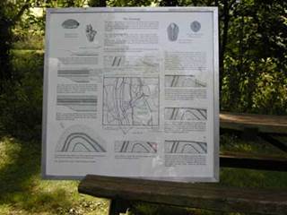
- 440 – 400 mya [million years ago] Silurian – shales, limestones, sands and gravels laid down.
- 395 or so mya Devonian – overlayer of river estuary deposits – sands and silts [Old Red sandstone].
- 350 mya – major earth movement creating Malvern anticline.
- Erosion planed off anticline to a roughly level surface.
- 280 mya – Permian – water laid down layer of angular pebbles [were called Clent breccias, now Haffield breccias]
- 215 mya – desert conditions producing sandstones in basin to east.
- Major faulting – along line of East Malvern fault. Worcester basin dropped 1000s of feet. Left newer rocks adjacent to older deposits.
Evidence around reserve:
- Opposite entrance red face of Triassic sand dunes.
- Down drive in reserve Haffield Breccia exposed, culminating in Huntsman Leap.
- Below Leap and following adjacent stretch of river is the line of the East Malvern Fault.
- Rest of reserve is on remains of anticline and composed of variety of Silurian rocks.
- The power of water based on quotations from Edwin Lee in 1856 [see below] and on the flood damage in recent years.
Impact of glaciation
About 500,000 years ago before the last periods of glaciation the wider picture suggests that:
- River Severn turned north in Shrewsbury area to enter Irish Sea at Dee estuary.
- River Teme flowed south to Leominster and then west via River Lugg and into River Wye.
- River Avon flowed east as part of Baginton – Lillington River into Norfolk area.
Local drainage was then based on:
- River Mathon flowing southwards from Bridgenorth/Kidderminster area down the west side of the Suckley Hills and then Malvern Hills to the Gloucester area.
- Leigh Brook would have been flowing westwards to join the River Mathon with water taken from the present River Stour catchment area.
From about 450,000 years ago [late Anglian Time] ice advanced down the east side of the Malvern Hills and then turned westwards [see picture below]. This then dammed back a lake covering an area from south of Eastnor northwards to near Longley Green on the western side of the Hills. The subsequent melt water from the ice together with the possible overflow from the lake carved out the gorge within the reserve and so reversed the river flow here to what we see now.
Meanwhile on the larger scene we had the creation of the Ironbridge gorge near Telford to bring the River Severn onto its present route and the diversion of the River Teme via the gap at Knightwick to meet up with the Severn near Worcester. Without the flow of the old River Mathon we are left with a watershed near Colwall with the relatively minor Cradley Brook flowing north to join the Leigh Brook and the equally small Glynch Brook flowing south.
Much of the evidence for the developments in the Mathon/Colwall area come from a paper by W. J. Barclay called A middle Pleistocene paleovalley – west of the Malvern Hills and published in the Journal of the Geological Society in 1992. The paper contains a detailed analysis of the deposits from the old Mathon river which include sandstone pebbles and coal fragments from the West Midlands and volcanic rocks and pebbles from the Welsh borderlands. On top of all these are glacial till deposits.
Summary
Clearly what has been summarised here is an oversimplification of the timescales and processes involved. It is still a work in progress building up the evidence as research techniques develop.
Pictures of the walk

Jim explains what we will see, and the local geology

A small exposure of Haffield Breccia

The weir at the Knapp
On the walk

Papermill Cottage
Extracts from Edwin Lees book Pictures of Nature of 1856
‘PICTURES OF NATURE’
In 1856 Edwin Lees published his book ‘Pictures of Nature’ that included descriptions of excursions of the Malvern & Worcestershire Naturalists’ Club.
One of these excursions took place in the area around the present Knapp & Papermill Nature Reserve.
LEIGH BROOK FLOOD - 1852
Lees also describes the floods of Leigh Brook on September 4th 1852 as reported in the ’Worcester Herald’ (in typical flowery Victorian prose); ‘’The storm commenced in the south-west. On the line of Leigh Brook was the most fearful amount of devastation from the brook, swollen into a prodigious body of water, swept over the country in a torrent nearly 200 yds wide and , in places, nearly 20ft deep above the normal level. Houses and bridges were swept before it, some orchards were totally destroyed, the trees being washed and wrenched out of the earth, great timber trees were laid prostrate and their huge arms torn asunder. The water brought huge landslips into the boiling torrent, and great masses of solid brickwork were carried great distances. All of the mills most severely. At Tundridge Mill a cat was found mounted on a flitch of bacon hanging from the roof. The devastation of this fearful night was nowhere experienced worse than at Bridge’s-Stone Mill, where Mrs Dandy, her two daughters, son and a servant narrowly escaped with their lives. The house received the full force of the flood, which stove in the greater portion of the wall rushed through the apartments, and almost immediately afterwards the wall at the opposite extremity gave way. The furniture was all swept away, and their cries for help, were heart rendering. Large flag-stones were forced up from the kitchen and carried to the meadow adjoining, the garden walls were levelled , and altogether , such a scene of watery was scarcely ever presented before in Worcestershire. The weir was carried away and the bridge totally destroyed. (NB: this would have been the road bridge adjacent to the entrance to the reserve). The bridges at Hopton Court and Leigh were also destroyed. A large hayrick was carried over several hedges and deposited in a field a quarter mile off. Hundreds of sheep and fowl were drowned.
GUNWICK PAPERMILL
Lees describes his memories of the Papermill;
‘’He describes the ruins of the mill and recollects the mill when a ‘little depressed Welshman, struggling with poverty and a large family, tried to make a living by manufacturing a very coarse cap-paper. The poor fellow had a long way to take his paper to purchasers by bad roads in a groaning, rickety, yawning cart drawn by a stumbling half-starved horse. He eventually gave up and moved to Australia and the mill fell to pieces and no one cared to rebuild it’.(NB: We can assume that the ruins were then swept away in the flood of 1852).
CALLOW’S LEAP
On a walk Lees describes the rock wall alongside the track down to the present reserve’s orchard; ‘The first point of interest I brought my friends to was Callow’s Leap, a precipitous rock overhanging a deep glen in which a swift stream chafes and roars over the jutting-out rocks below, and so called from some vague tradition of a ‘callow’ hunter, who once leapt over the rock in the excitement of the chase, though the result of his leap is unrecorded’.
Ice Age draining of the area
This information is from The Geopark Way, published by the Earth Heritage Trust. Additional information on the geology of this area is provided in this excellent guide. You can purchase it from Herefordshire and Worcestershire Earth Heritage Trust; Geological Records Centre; University of Worcester; Henwick Grove; Worcester WR2 6AJ (01905 855184).

Picture 1
The dry river valley which can be seen between Ledbury and Colwall has no water running through it now. It is thought that half a million years ago a large river flowed there, running north to south. Known as the Mathon river it was comprised of one river flowing from east to west [i.e. the opposite direction to the current flow] through the Knapp and Papermill and a second one running southwards on the west side of the Suckley Hills.
Picture 2
450,000 million years ago the Anglian ice sheet removed the sources of these rivers. Melting ice from glaciers deepened the gorge at the Knapp. Further south the ice blocked the river, forming a lake in the Colwall valley.
Picture 3
When the ice finally melted, it left an altered river pattern. The small Cradley Brook then flowed north, a reversal of the initial Mathon River. It joined the Leigh Brook and flowed through the deepened Knapp and Papermill gorge. A second ice movement to the north saw the River Teme diverted through the Knightwick Gap.