Forest of Dean
14th September 2011
On 14th September 2011 members of the Malvern U3A geology group met to undertake a coach trip to the Forest of Dean, led by Alan Gray.
The morning consisted of a visit to the Geomap Project at New Fancy, followed by Hopewell Drift Mine, east of Coleford.
In the afternoon we walked the Soudley Valley Forest of Dean Rural Geology and Landscape Trail. This trail can be purchased for £2, available at the Gloucestershire Geology Trust (info@glosgeotrust.org.uk) ,The Tithe Barn Centre , Brockworth. GL3 4QU. Click here.
For
a write up of the mornings excursions by Liz Daniel, click here.
For pictures, click here.
For a write up of the afternoon walk, click here.
For pictures, click here.
To view a geological map of the area click here,
and set the search box for Upper Soudley. View from here to Ruspidge in the
North.
Write up of the mornings excursions
An excellent overview of the geology of the Forest of Dean was presented to us on arrival at the Geomap Project on the site of the New Fancy Coal Mine, about 3 miles south-west of Cinderford. This outdoor map shows the surface geology with each section made up with a piece of the actual stone mined locally. The whole Forest area comprises a syncline of Carboniferous limestones and coal measures lying on older Devonian Old Red Sandstone. The syncline is a result of folding in the Variscan Orogeny. The map also shows the site of collieries, coal mines, as well as railways and tramlines.
It is believed that coal and iron ore were mined here from Roman times onwards from surface excavations but in the 19th Century deep mines were necessary to extract the minerals. Mining peaked in the mid 20th Century. Stone was used for local buildings and for lime production.
We then proceeded to a viewpoint situated on a former spoil heap, where we saw commercial forests in front (looking east) and original forests behind. It was explained that the limestones were formed from precipitation in a warm sea when ‘England’ was situated near the Equator. This is the source of most of the iron which came about via iron-bearing solutions descending from rocks above. The coal measures formed from alternating layers of carbon produced from trees fallen into swamps with very little oxygen, and then covered by silts. They were ultimately changed by pressure and heat. Originally, the trees were used to make charcoal which burns at a high temperature necessary for the smelting of iron ore.
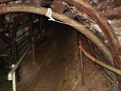
Later, we were taken to the Hopewell Drift Mine (coal) which is a shallow mine, having a maximum ‘cover’ of 90 ft to 100 ft – the miners would walk into it rather than descending into it via a shaft. Our guide was an actual miner and he explained how the coal was mined and the conditions and dangers in former times as well as today. Ventilation was by convection which could be enhanced by use of a furnace + chimney which drew air into the mine for both the men and horses working there. Fortunately, there is no methane so fires were not possible. Beside the rail tracks, along which the trucks carried the coal, was a channel which enabled flood water to escape after heavy rains. At one point was ‘a band of clod’ a mudstone with bands of coal – this can be dangerous as it is weaker and arched metal and wood supports were need to keep the roof safe.
Finally, we arrived at the ‘coal face’ - there was a seam about 30 – 32 inches deep rising gently upwards from us. A jib would be used to undercut the coal which would then drop into a pan and then into a cart to be hauled away along the rails by a horse. The resulting space would be packed by pit props until it could be packed by ‘gob’ (rock from the surface). This would slow compression by the rocks above. Another danger is ‘black damp’ or carbon dioxide near the ground and this could be poisonous to the miners. We were shown one fossil common in the coal measures – stigmaria, a root fossil. Our guide said he had once seen a large part of a trunk lying fossilised above him.
After a gentle climb to the surface, we ended our tour – an excellent example of practical geology.
Pictures from the morning
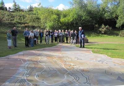
The group examining the Geomap layout at New Fancy.
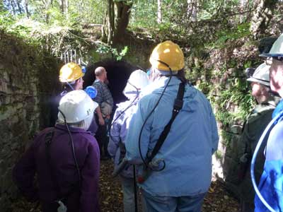
One group about to enter the Hopewell Drift Mine.
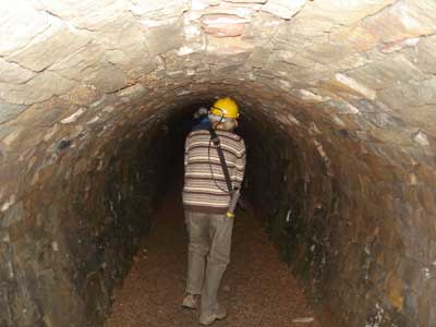
The low ceilinged tunnel within the mine.
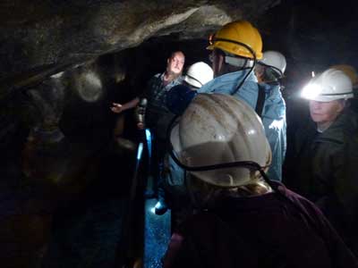
Our guide explains the workings of the mine.
Approaching the coal face.
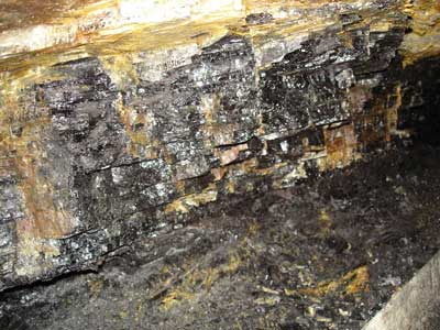
The coal face itself.
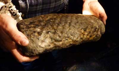
A stigmaria, a tree root fossil. This had been discovered during previous mining work.
Write up of the afternoon walk
The afternoon’s walk in the Soudley Valley gave us a wide appreciation of the rich and varied local geology. Our trail along the steeply sided valley led us to places where industrial activity and weathering have left exposures, so the rocks are clearly observable. The rocks have been deposited by different processes in a number of environments . The trail of seven sites follows the progression from one environment to another covering nearly 100 million years of the Earth’s history .
Under Alan Gray’s tutelage we energetically set out for Site 1 (SO 6541 1045), the Railway Cutting, where Devonian Old Red Sandstone (400 million years old) has been laid down by a large river system. The ancient rocks are interspersed with hard quartz conglomerates, used locally as grindstones.
Having established the beginning of the rock sequence, we strode on to Site 2 (SO 6533 1074), The Lower Blue Rock Quarry, where the Carboniferous Limestone illustrates clearly the progression from the Devonian rock (of Site 1), laid down by water, to the Marine rocks formed by the sea moving in to cover the dry land of the Devonian. Then, by precariously climbing a steep flight of steps to Site 3 (SO 6532 1086), the Upper Blue Rock Quarry we were able to see where deposits of this lime and also sandstone had been worked.
From the top of the quarry the trail led along a gulley where we paused to look at a cobbled stream. A feature of the area, the watertight sides and bottom, prevent seepage into the mine workings beneath.
The upward path took us, with some discernable puffing to Site 4 (SO 6532 1135), Shakemantle Quarry. This beautiful exposure has been created through the mining of Lower Dolomite, a hard rock used as an aggregate. The action of evaporating sea water and magnesium on the rocks of Site 2 have given rise to this more recent unit of the Carboniferous Limestone Series. A further member of the series, the iron containing Crease Limestone lies towards the top of the quarry. We stood awhile enjoying the scenery of the conifers on the jagged cliffs. Then, our route took us past old brickworks and the remains of an iron mine where the Crease Limestone had been worked.
At Site 5 (SO 6521 1121), Perseverance Road Cutting, the Crease lime is overlain by a further form of limestone, Whitehead Limestone, so called because of its colour and it’s position above the Crease Limestone. The uppermost member of the Carboniferous Limestone Series , Drybrook Sandstone, we found a little further uphill at Site 6, Shakemantal Sand Quarries, where it may have been deposited in an esturine or deltic environment.
Our last Port of call was Site 7 (SO 6513 1061), Chimney Scowle. A scowle is the eroded channels of a cave system where mining of iron containing Crease Limestone took place; scowles are unique to The Forest of Dean. The chimney at this site was built to ventilate the iron mine workings below.
The trail completed, and delighted with the days interests and discoveries, we were pleased at last to descend to the Heritage Centre for tea, cake and a some humorous conversations about the day’s goings on. The talk accompanying the trail, given by Alan Grey was, as ever, well informed and well executed. The group are grateful for his competent leadership.
The tour provided interest for all tastes. The abundance of geological information would satisfy the most ardent of students; for those of us with a more passing interest our leader Alan Grey’s descriptions and explanations of the rocks’ history illuminated and enlivened the experience. Those who had attended Richard Edward’s lectures earlier in the year, had ample opportunities for fitting the theory with reality.
Pictures from the afternoon
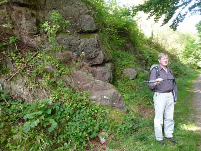
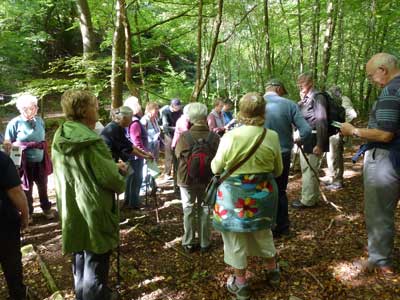
Our guide, Alan, explains the
geology at Site 1, Railway Cuttings.
In the walk we progress through 100 million years of the Earth’s history,
starting here at the oldest.
The rocks behind Alan are Devonian, “Old Red Sandstone”. These are called
“Brownstones”.
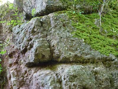
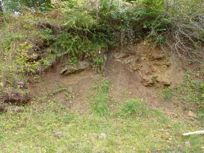
A close up of the rocks at Site
1.
To the left we see the Brownstones: mudstone, sandstone and conglomerate laid
down by a large river system in Devonian times.
On the right is a much coarser grained rock, a quartz conglomerate.
The unconformity
separating the two is clearly visible, running top to bottom.
Site 3, Upper Blue Rock Quarry,
showing two limekilns.
The lime was extracted from the rocks by setting fires in small excavations.
The rocks here are Lower Limestone Shale,
the lowest division in the Carboniferous Limestone Series.
The group on the upward path to Site 4.
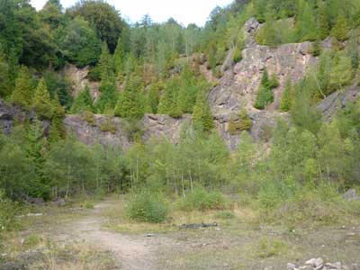
Site 4, Shakemantle Quarry.
A large exposure through the Lower Dolomite unit of the Carboniferous Limestone
Series.
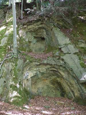
Site 5, Perseverance Road
Cutting.
Here Triassic sediments are
surrounded by Carboniferous rocks.
The Triassic sands were laid down in a wadi some 100 million years after
the formation of the Carboniferous limestone.
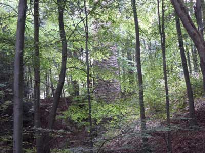
Site 7, Chimney Scowle.
Pictured here is a ventilation chimney for the Perseverance iron mine.