Leckhampton Hill
The Leckhampton Hill site
Grid Ref: SO95061795 (Brownstone car park).
Importance: These disused quarries expose an almost complete sequence of the Cotswold Middle Jurassic, Inferior Oolite rocks, plus the uppermost part of underlying Early Jurassic, Lias Group.
Further information: For £1.95, a trail guide to Leckhampton Hill is available at the Gloucestershire Geology Trust (info@glosgeotrust.org.uk) ,The Tithe Barn Centre , Brockworth. GL3 4QU. Click here.
Visit report
The Leckhampton section of the field trip is written up by two comparative newcomers to the geology group. They have brought a fresh approach to their accounts of the shorter and longer walks.
The shorter walk at Leckhampton
Well, we drew the short straw….the one wet day! However, the easy version of the Leckhampton trip was really accessible – not too far to walk and on the level – and not too muddy! More importantly, there was still a lot to see.
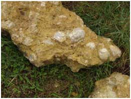
We were able to view the ‘Brownstone’ limestone rock in situ, and pick up bits for closer study.
Very nearly every piece of rock was embedded with fossils.
It was very noticeable that this limestone was much denser than the Oolite we had seen before lunch, and didn’t have the same texture. We were told it was younger than the Oolite, and that in fact the older stuff was under our feet. I did wonder why there was such a difference in two types of rock as they had apparently both been deposited from “warm shallow seas”, albeit at different times.
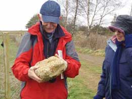
After a short circular walk we returned to the coach, and were offered the chance to get back on. However, for the not completely worn-out, there was the opportunity to enter the base of the quarry, via a short slope, to search for more fossils.
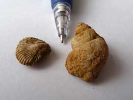
I got lucky and found two small fossils that had lost their surrounding rock.
The gastropod (on the right) was deemed sufficiently interesting to be passed around the coach during our return journey.
All-in-all a very interesting trip, well thought-out with the needs of the less-mobile in mind.
The longer walk at Leckhampton
My first geology outing and almost my first geology lesson so I learnt a lot on the Leckhampton trip.
I’m of course disappointed that it is not my job to write about ‘solifluction porridge’ but I can throw in some of my new vocabulary of 'scarp and dip' that we walked along, not far from the edge of the scarp. Our first stop was to inspect what looked very like manmade dry stonewalls but was in fact a natural occurrence. We were encouraged to observe, asked to compare what we were looking at with the limestone we’d seen earlier in the day, to look at the bedding planes and decide how they had been deposited. I listened in to people talking of shallow turbulent water action that our leader later endorsed. This was Trigonia Grit – limestone but in a different form from that seen at Crickley Hill.
We continued on at a pace to Deadman’s Quarry pausing to look at examples of gryphia fossils, referred to as Devil’s Toenails easily seen in stones, presumed found in local fields but left handily by the path for easy observation.
Scrambling down into the Quarry we saw big blocks of limestone separated by a prominent horizontal line of 'hardground'. This marks where the deposition of regular beds has been replaced by the development of an eroded sea floor environment. There was also cross-bedding, evidence of the way beds of limestone had been affected by currents in the shallow seas long ago. We looked up to the very top of the quarry where we could see a thin layer of Lower Trigonia Grit, a much coarser, rubbly limestone, known for the amount of fossils to be found in it. Immediately below this was an unconformity – probably my favourite new usage – and then the Upper and Lower Freestones that were separated by a thinner band of Oolite Marl.
We saw an example of a 'gull', a prominent vertical crack formed by water exploiting a weakness at the surface and moving straight downwards under gravity, which had partially filled with rubble. The rock was in places stained red, but we are not sure of the cause. Elsewhere the rock had a surface of brown travertine, a form of dripstone. The talus on the quarry floor was evidence of local and recent erosion.
On the way back we admired the Devil’s Chimney, a striking pillar of Lower Freestone, a folly left by the quarrymen. We scavenged for portable pieces of old disused limestone walling with plentiful fossils, looking like bargain hunters at a jumble sale. And finally stopped to admire the use of the various forms of limestone and other building materials in the farm buildings near to the car park.
A good leaflet explains all this and gives the geological information that you may by now be pining for. It is published by Gloucestershire Geoconservation Trust in the form of a rural geology trail on Leckhampton Hill.
Plenty of well-presented and interesting information, a good walk, stunning views, enjoyable company and not much rain made for a memorable day out - thanks to everyone.
(Imagine my pleasure when I walked round Bath a few days later, admiring the beautiful buildings and explaining about the building blocks of Oolitic limestone to my friend).
Pictures on the two walks
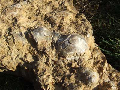
Examples of the bivalve fossil Grypheae, also known as
‘Devil’s Toenails’.
Many of this were found on the path north of Brownstone Quarry, leading to the
trig point.
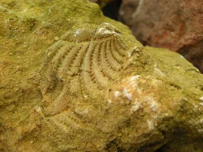
Another bivalve fossil, Trigonia.
This was found in Brownstone Quarry in the Trigonia Grit exposure.
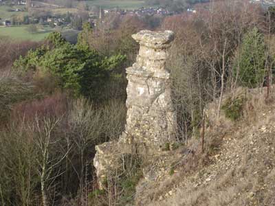
Devil’s Chimney. This is a pillar of Lower Freestone rock, left as a folly during the quarry process.
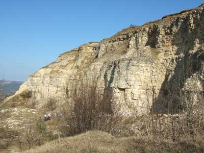
Deadman’s Quarry. A large Inferior Oolite quarry, with both Upper and Lower Freestone rocks.
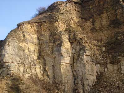
A close up of Deadman’s Quarry.
Note the Lower Freestone below, with a thin layer of Oolite Marl above it.
On top of the Marl comes Upper Freestone.
The Oolite Marl is a fine lime-mud containing many fossils.