Ross-on-Wye
13 July 2011
The U3A geology group organised a trip to Ross-on-Wye on Wednesday 13 July 2011. The visit was in two parts. In the morning we went on a 1½ mile walk in and around Ross based on the Earth Heritage trail guide. In the afternoon we had a choice, either a walk to the promontory hill behind Ross, or a visit to Wilton Castle.
Click here for
Report on the morning walk - Pictures of the walk
Report on the afternoon walk – Pictures on the walk
Report on the visit to Wilton Castle - Pictures
To view a geological map of the area click here, and set the search box for Ross-on-Wye.
Report on the morning walk
Nineteen members of the Geology group visited Ross on Wye on the 13th July, a trip organised and led by Elizabeth Staley and Mary Geffen, to whom we owe our thanks. They also provided a number of most useful hand outs. The visit was split into a morning session, where the group stayed together visiting a number of locations around Ross, and an afternoon session when part of the group visited Wilton Castle with Mary and the remaining part visited Chase Wood with Elizabeth.
Much of the route we followed was based on the Earth Heritage Trust trail guide produced for Ross-on-Wye. This can be purchased from Herefordshire and Worcestershire Earth Heritage Trust; Geological Records Centre, University of Worcester, Henwick Grove, Worcester WR2 6AJ (01905 855184) ; cost around £2
Ross, built on a bluff above a meander of the River Wye, is a pleasant ancient town with a 13th century church, a 17th century Market Hall and fine houses built of local stone. Access to the river, where there was a crossing, was made across the meadow flood plain. The bluff, made of red sandstone rock, was cut by one of the meanders of the River Wye and it is these features that occupied our morning.
Our leaders, henceforth to be known as EM, provided a geological background to the scene of the river and the red cliffs that form the bluff. They reminded us how the orogeny following the 'collision' between Avalonia and Laurentia had produced the Caledonian Mountains across northern Britain. As these mountains eroded, sand, gravel and other debris were transported southward by periodic floods and braided rivers. Over time the braided channels have been replaced by the meandering Wye which has had a strong influence on the landscape and development of Ross.
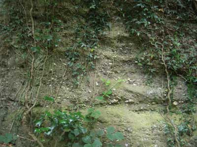
The cliffs of Ross, now labelled as from the Brownstones Formation of the Old Red Sandstone Period of Devonian age, are of rocks formed from this debris at a time when “England” was south of the equator in a hot and arid, that is a desert, environment. Their red colour is caused by the oxidation of iron to form haematite. There are two forms of sedimentary beds revealing different textures, in that one is formed of fine grained consolidated sandstone while the other, usually thinner and alternating with the first, is made of coarser sandstone containing pebbles, quartz and clay parcels. This latter bed contains numerous holes where the clay has been removed. The difference between the beds reflects the change from quieter conditions when fine grained particles were dropped to flood conditions when the heavier particles were transported some distance before being dropped when the flood slowed.
Another feature is the presence of crossbedding where the deposited sand builds up sandbanks which move in the direction of the current. Although the dominant colour is red, there are green bands within the red beds presumably a result of reduction to ferrous oxide caused by the breakdown of vegetable matter.
An animated and prolonged discussion (a clock around the rock) took place about a number of the features of the rock beds with an inconclusive conclusion.
We walked from the cliffs across the flood plain meadow to visit the Wye, where EM explained the formation of the meanders of a river. Meanders usually occur on well developed flood plains with a river channel that has a shallow gradient, the Herefordshire floodplain for example. Variation in water depth and bank uniformity will cause the current to swing to one side of the channel, speeding up in the process, and eroding that side more quickly. Once started the meander grows, cutting any rocks on the outer bank and depositing sediment on the inner bank. The wavelength of a meandering river seems to be about 10 times the river width when the river is at the height of the bank. Meanders are dynamic in the sense that they are moving with time across their flood plain, and can extend their erosion to such an extent that they form a neck that can eventually be cut through leaving an “oxbow lake” or if without water an abandoned meander. It is thought that this may have occurred sometime during the Pleistocene.
This last comment led us to walk across a pleasant riverside park to a stream, the Rudhall Brook, whose oversized valley runs “inland” from the river just above the tight meander adjacent to the cliffs. It has been suggested that this steam is the remains of an abandoned meander which runs around Penyard Park and Chase Wood before returning to the current Wye.
A walk through the town allowed us to see some of the houses and the church built of the stone we had been discussing. The church leads to a fine park, Prospect View built by John Kyrle, and overlooking the town with extensive views to the NW, W, and SW.
Pictures of the morning walk
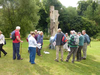
The group assembling at Wilton Road car park, awaiting a geological overview of the area from Elizabeth and Mary.
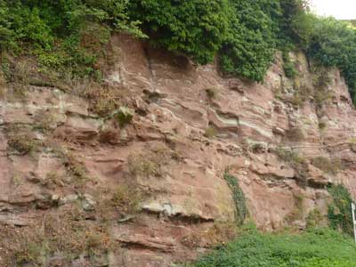
The river cliffs on Wilton
Bridge Road. Note the difference between the fine grained consolidated sandstone
and the coarser sandstone.
Also the difference in colour between red and light green, highlighting the
degree of oxidation when the rocks were laid down.
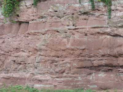
A good example of cross
bedding.
It is possible to determine the direction of current flow when the sandy
sediments were laid down.
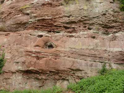
A view of the cliffs at the
bottom of Wilton Road.
The deposition here seems to be during a period of increased water flow. The
holes are where clay pebbles have been deposited and, being softer than the
surrounding rock, have been subsequently weathered away.
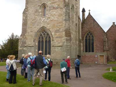
St. Mary’s Church.
The tower on the left is built of Tintern sandstone.
The nave and chapel on the right are built of Brownstones.
We observed some interesting
rocks on the wall outside Edde Street bar park.
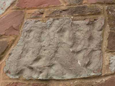
#1. The surface of this rock shows ripple marks,
which were formed in channels in the same way that we see ripples developing in
shallow water today.
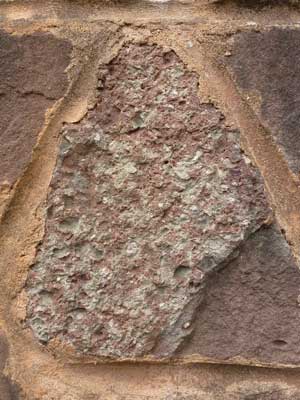
#2. This rock is a calcrete, It was formed in a arid climate when lime-rich ground waters evaporated leaving behind calcium carbonate which cemented the particles in the fossil soil.
Report on the afternoon walk
Nine of us set off on the afternoon walk up Chase Wood Hill, led by Elizabeth Staley. This wooded hill is largely comprised of Brownstones, as studied on the morning walk, but is capped by a layer of harder Quartz Conglomerate (QC), overlain by a band of Tintern Sandstone. After a general view of the hill from a gently upward sloping field, we started to climb quite steeply through the woods, noticing quartz pebbles on the path and small fallen blocks of QC. Almost at the top of the Hill, we came to an outcrop of Quartz Conglomerate (Upper Devonian), and noticed an unconformity where the middle Devonion was missing. The QC was formed in a south flowing river system and Elizabeth suggested we look for a tile-like formation (imbrication) indicating the direction of flow.
We then had to work out things for ourselves. After close inspection, we decided that a huge bolder (QC) had been displaced and fallen so that the bedding planes were at a completely different angle from the ones in situ. The QC is a hard rock, in the past used for making cider-crushers. Higher up we found an outcrop of rock that was pale orange when broken. We assumed this was the Tintern Sandstone – a more weakly cemented rock than the QC.
After a pleasant walk through the woods, we came to a view of Howle Hill. The intervening valley is an abandoned meander (mentioned this morning) possibly cut during the Cretaceous period. As we continued there were several other view points and other sightings of the QC and sandstone. Towards the end of our walk, we came to a cutting through the QC which was clearly the way into the Iron Age Fort once situated at the top of the hill. We debated as to whether this was wholly man made or the excavation of a natural break or fault.
Finally, as we rounded Chase Wood, we could look eastwards towards Penyard Hill, separated from us by a valley running in a NNW/SSE direction with a fault line parallel to it higher up. This hill is also an outlier and similar geologically to Chase Wood.
Pictures of the afternoon walk
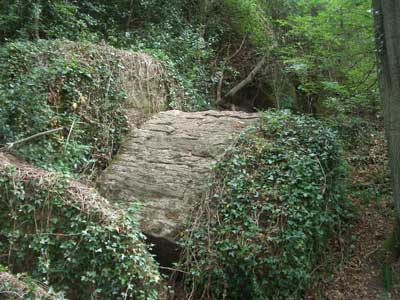
Blocks of Quartz Conglomerate on the walk to Chase Wood Hill
Tintern Sandstone with Quartz Conglomerate.
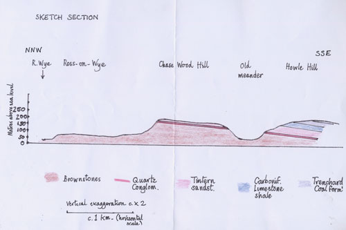
Elizabeth’s sketch section of the geology on Chase Wood Hill
Report on the visit to Wilton Castle
For those of us who did not fancy a walk up Chase Hill after lunch, the afternoon offered an alternative, tea and cakes in the magnificent gardens of Wilton Castle. Also included was a bit of geology on the side.
The castle itself was built in the twelfth century using locally available sandstone. This was from the same Brownstones formation we saw in the morning, the formation being Lower Devonian, also called Old Red Sandstone. The red colour is due to the fact that the rocks were deposited in arid conditions, where the iron in the rocks became oxidised.
The house and castle have been built on a river terrace for height. A river terrace is a former flood plain of the river. In the fullness of time these terraces will be destroyed as the river meanders.
The castle is currently undergoing major restoration under the guidance of English Heritage. The work already done shows how wonderful this will be on completion.The gardens were beautifully kept with lots of colourful and interesting plantings. The tea and cakes taken in the shade of an overhanging apple tree were most welcome.
A very interesting alternative and one we would not have seen unless shown where it was, well off the beaten track. A very good afternoon.
Pictures of the Wilton Castle
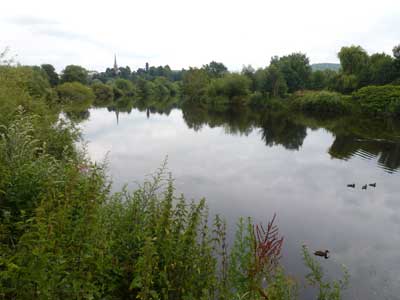
Ross-on-Wye as seen from Wilton Bridge
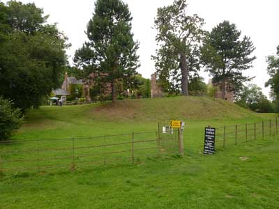
Wilton Castle. The river terrace on which it has been built is clearly visible.
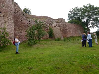
The walls of the castle, constructed using the local Brownstones.