Buxton Trip
24 – 27 September 2012
This was the Malvern U3A geology group’s third residential trip, following on from visits to Dorset and North Wales. We stayed in Old Hall Hotel in the centre of Buxton between the 24th and 27th of Septemcer, 2012. Report kindly provided by Bonni Sinclair.
Click here for
Useful background reading
Itinerary
Report for the 24th
Report for the 25th
Report for the 26th
Report for the 27th
Useful background reading
For anyone wanting an introductory text in their hand we recommend “Classic Landforms of the White Peak” published by the Geographical Association [ISBN 1 899085 60 2] from about £9.95 secondhand [and its companion for the Black Peak] or, for a little more detail and with excellent images and diagrams, Trevor Ford’s “Rocks and Scenery of the Peak District” [ISBN 1 84306 026 4],which is available secondhand from £2.94.
Monday 24
We all safely arrived in the Splash Car Park, although some more soaked than others and some with tales of watery adventures to tell.
I think I won the prize for most soaked, having chosen not to wear water-proofs on my trot across from the Link – although perhaps I shoud change ‘prize’ to ‘stupid prize’.
It’d rained since the afternoon of the previous day and continued relentlessly, without pause, until Wednesday.
We arrived at the Peak District Mining Museum at Matlock Bath, not too behind schedule and spent an instructive time there familiarsing ourselves with the mines and minerals of the area before setting off for the National Stone Centre for guided tours.
The National Stone Centre and its Quarries
(120 disused lead mine shafts, 6 abandoned quaries and 4 lime kilns)

As I’d been before, I chickened out and stayed in the dry to study how stone was formed in the ‘Story of Stone’ in the Discovery Centre. The Millenium Wall was much admired. Built by members of the Dry Stone Walling Association working in their traditional styles, they created a display wall of 19 six metre long sections. Learning that crinoids (sea lillies) could be 2m high was also rather astounding. Time and again we were to marvel at the idea of walking at the bottom of the shallow seas when the UK was south to the equator some 350 million years ago.
Tuesday 25
We went to look at the Bee Low Limestones of Millars Dale, following the road alongside the River Wye as far as Litton Mill and walking through millions of years. Descending the Derby Dome - as evidenced by the gently sloping limestones - into a warm tropical sea and then rising again into later shallow seas.
The Bee Low limestone is more white and porous and contains more visible fossils than the greyer Dinantian limestones - which are 98% calcium carbonate, formed from shells of minuscule plankton, the organic matter giving it a more grey appearance.
And did you know that rocks smell? Give it a good scratch and have a sniff.

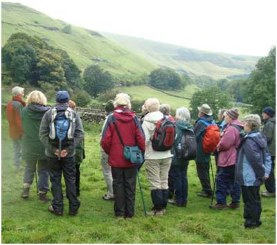
Listening to Dr Peter Webb’s erudite and graphic descriptions.
Continuing along the road we were priviledged to be told why the water was spewing out of the bank – a junction where the permeable white limestone lay on top of the basalt and probable at the base of a fold.
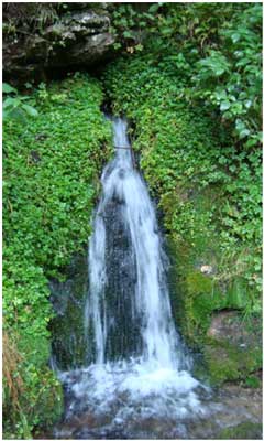
A water-spout at the junction of limestone and impermeable basalt from a lava intrusion.

Millars Dale Bee Low limestones.
Further along a protruding shelf caught the eye; a bedding plane where the lower level had been eroded and clearly exposed the underside of the later deposition.

At the junction of limestone depositions at different times, we looked for fossil imprints or protrusions on the underside of the shelf.
And here they are – Gigantoproductus.

Crossing the River Wye we had a lunch stop with a difference, in the Monsal Trail tunnel. At least it was sorta dry there. Continuing we paused to admire from the other side of the gorge, the limestone cliffs we’d been walking in front of.

After a stop to look at and sniff the grey deep water limestone and a hunt for chert, we went into the limestone kilns of Millars Dale before boarding our coach. We all elected not to visit the dolomite exposure and even Peter seemed thankfull. Well he was going out that evening.
Wednesday 26
Our bus carried us into Hope Valley near Castleton, from where we could burrow into the reef limestone, formed some 330 million years ago, through Treak Cliff Cavern.
Miners in the 1750s tunneling into the cliff in search of lead came across some black rock (bottom left of picture) which on closer inspection in daylight proved not to be lead or coal, but rather a pretty blue-ish crystalline rock, which was then used for artifacts.

Blue John samples of rock still mined today.
Inside Treak Cliff Cavern peering at the multi-coloured flowstone adorning the walls.

Or wondering at the stalactites: in this cave stalactites take 1,600 years to grow 1cm.

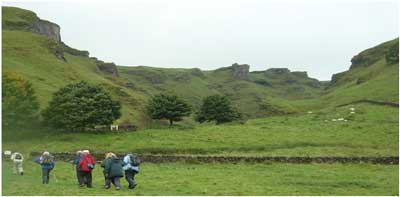
Here we are standing in the sea lagoon wondering if we’ll ever get over those reefs. You might just pick out the entrance to Treak Cliff mine above the middle tree.
Or, we could just head up through Winnats pass, eroded through the reef margin of White Peak.
After a short walk back to Castleton for lunch we set off again in the bus to access the old A625 which was defeated by the shivering mountain – Mam Tor. Mam Tor is the site of two Bronze Age burial mounds dating from 5,000 to 3,500BC. A late Bronze Age village and hill fort can be seen.
Mam Tor has alternating layers of friable shales (mud stones) and sandstones called cyclothems which tell story of alternating periods of deep water and times of shallow.
The excess water in the layers creates a very unstable structure. About 3,600 years ago Mam Tor began to move and at some point a major landslip occurred.
In 1979 the main A road was finally closed because of subsidence. The landslip is still moving an average of 9cm per year and is likely to remain unstable for at least 1,000 to 1,500 years more.

A road slipped.
Below, cyclothems of Mam Tor.

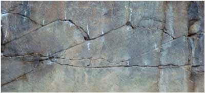
Are there any interesting identifiable geological features here? Jim thought he found a slickenside.

Thursday 27
Visit to Buxton Museum
A lump of limestone packed with the calcareous skeletons of crinoids, sea creatures like the tube-worms of today. The bottom corner is polished.

A very rare stone is the black marble from Ashford-in-the-Water.

Leaving the museum we took the country route to New Mills; seeing dry valleys with running water and able to appreciate the dramatic peat-covered gritstone moorland of the Dark Peak; the gritstones being formed about 320 million years ago, from the deposited layers of sand washed over the limestone beds by river deltas, and contrasting with the older limestone uplands and pastures of White Peak.
At the site of Torr Mill, just at the junction of River Sett with River Goyt, is now Archie. Archie is an Archimedean screw powering a hydroelectric scheme – one of the first to be used in the UK. The work was begun in March 2008 and completed by September. Archie is screwed by the weight of the water flowing down it and provides clean, renewable power to the local Co-op store. The surplus is sold to the National Grid.
Torr Vale Mill is an excellent example of the influence of landscape on early industrial development. The mill was built for water powered spinning in 1788-90 by Daniel Stafford.

Torr Vale Mill (above) was one of several mills using the gorges of the Rivers Sett and Goyt whose waters provided the power. Torrs Gorge was carved 15,000 to 20,000 years ago by the erosive action of glacial meltwater.
Woodhead Hill Sandstone rock exposure under the viaduct into New Mills, showing joints bedding, and history in the making.

And lovely ripple marks.

And so a Geology trip is not just a picture of understanding what makes our landscapes, but a discovery too of the archaeology and history of the area.
To return to home page, click here.