Ludlow
12th September 2012
The U3A geology group organised a day trip to Ludlow on 12 September 2012. Click here for the itinerary of the day. The morning’s walk follows the Teme Bank Trail. This is available as a free download from the Shropshire Geological Society web site under “trail guides”. Alternatively, click here. This visit was inspired by the talk we had by Prof. Michael Rosenbaum in December last year on ‘The Lost Silurian Sea’ (click here) and follows up on much of what he said. The day was organised by Dick Harris and Geoffrey Carver.
Write up by Geoffrey
You might know Ludlow as the gourmet capital of Shropshire, a title well deserved, but you should know it too as a geological gem. If you didn’t take part in our late summer visit then you missed a treat.
The road journey only takes about 45 minutes and includes pleasant views of the Clee Hills.
Because it is geographically compact, Ludlow is easy to get around; even if you don’t go for the food or the geology then there is a superb range of architecture of considerable quality. However, I digress.
We began at the Museum, which has a small but very good collection of local fossils and good quality displays of Silurian geology. Perhaps more importantly it has displays of some of the original work by Roderick Murchison who defined the Ludlow Bone bed(s) as marking the end of the Silurian epoch.
Out into the fresh air we walked past the impressive outer walls of the castle and dropped down into Teme valley to start the Teme side walk where we looked at the very clear evidence for the Ludlow fault. There were many older buildings and structures, including the castle, built from the good quality stone found in the Whitcliffe beds which were our next stopping point. They are exposed along the western side of the river and form part of a small but clearly visible anticline and lie conformably on the Leintwardine beds which we found a little to the south. Also along this short section was a small cave system. On the opposite side of this quite broad, but shallow river, are some small flood plains.
The path starts to rise towards the end of the walk which passes through a former quarry which supplied local building stone. And on to Ludford corner to look at the SSSI which is the Ludlow bone beds. These are now marked by a plaque as the actual exposure had been extensively excavated by fossil hunters and so has now been covered to protect it. We also looked at a small exposure in the nearby road cutting, but could not find the narrow but distinctive bands.
After lunch overlooking the river we returned to the Library to view the Shropshire reserve geological collection. Judging from the expressions of pleasure and enthusiasm alone, this was a very rewarding experience. There were samples of minerals, and fossils from the Cambrian onward, and at last, several specimens of those elusive bone beds. The highlights were perhaps the fossilised remains of a small family group of mammoths found locally. It was a genuine pleasure to see such a wide range of material and be encouraged to handle it, rather than peer at it through a glass case.
Geology of the Teme Bank Trail
Firstly, a short description of the geology encountered on the Teme Bank Trail. The rocks under our feet were laid down in marine conditions, in a warm shallow sea on the edge of a continental sea. This occurred around 420 mya (million years ago) in the Silurian period. The Silurian is divided into four stages, namely:
Pridoli (younger)
Ludlow
Wenlock
Llandovery (older)
The trail contains rocks from three distinct beds, which are from the younger part of the Silurian, namely:
Ludlow Bone Beds (youngest -
Pridori)
Whitcliffe (middle - Ludlow)
Leintwardine (oldest - Ludlow)
These beds were subjected to gentle folding during the Acadian phase of the Caledonian orogeny. This occurred around 400 mya and resulted in an anticline structure. Note that after erosion, the oldest rocks are on the axis of the anticline. So, on the trail we see the following progression:
Whitcliffe > Leintwardine > axis of anticline > Leintwardine > Whitcliffe > Ludlow Bone Beds
Pictures
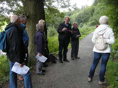
Geoffrey explaining the trail geology to the group. We are close to the axis of the anticline. The rocks here are the oldest on the trail at around 423 million years.
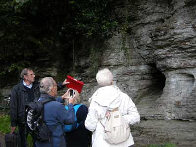
These are Leintwardine beds which consist of siltstones and thin limestones. The effect of water on the lime-rich rocks can be clearly seen, creating holes and crevices. This is towards the middle of the trail.
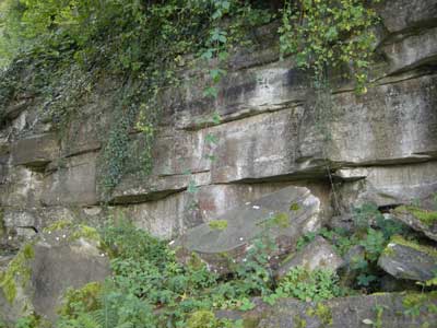
These are Whitcliffe beds, about three-quarters along the trail. The rocks were quarried and used for building work in Ludlow.
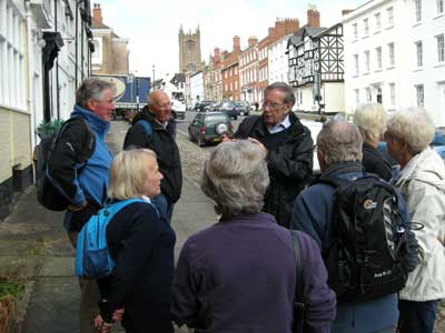
Geoffrey explains the interaction between geology and architecture, with Ludlow in the background.
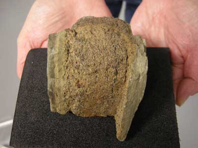
A sample of Ludlow Bone Bed from the geological collection in Ludlow library. Note the thickness! This is from the site at the end of the trail which is now impossible to see.
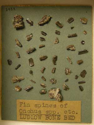
Fish spines from the Ludlow Bone Bed. Again from the geological collection in Ludlow library.