South Devon Field Trip
October 2014
The social and financial arrangements
This four–day trip consisted of a series of visits to coastal locations led by a professional geologcist, Dr Nicholas Chidlaw, who provided substantial printed information beforehand and expert hands-on demonstrations day-by-day. Each of the 20 participants independantly contributed to the cost of the professional course fe. This was very much in line with the study needs of some of our members, Transport and accommodation were arranged by members of the group. The trip arrangements were flexible enough to provide for non-geologists. Some shared the visit with their partners; some extended the visit into a holiday. The hotel meals were very good – even excellent - ; the weather was fine; the coastal scenery was new to most of us and very beautiful; the study locations were very well chosen. Altogether, it was a truly enjoyable trip.
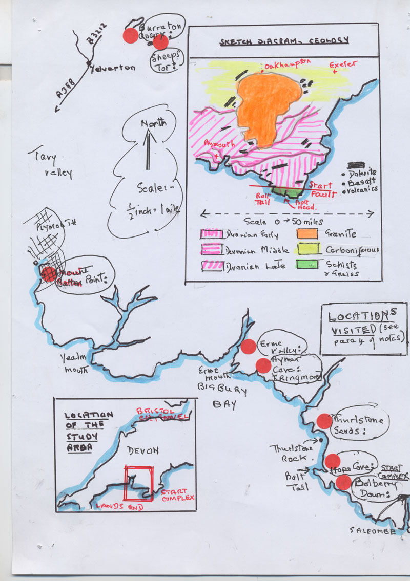
Nick Chidlaw took us to eight locations along the South-east to North-West line between Start Point and Plymouth and Northward to the edge of the granite hinterland of Dartmoor. Below (see para 4) is a description of each location with some geological detail .
Whitsand shale - silver rocks.
The Geological history in a nutshell
Three rock types dominate South Devon –
- Devonian slates, mudstones and sandstones are interbedded with rocks of volcanic origin.
- The Schists of the Start Complex lie against these slate/mudstone beds
- To the north of these is the Granite Pluton of Dartmoor surrounded by metamorphosed rocks created by the heat and pressure of the pluton’s aureole.
Three structural forces have shaped these rocks:-
- Tectonic plate movement in the very old oceanic crust created changes in sea levels
- The Variscan Orogeny produced mountainous faults, folding and over-folding
- Subsequently Climatic erosion reduced mountain ranges to the present plateau)
1. The Devonian Slates, mudstones and volcanics
The rocks of the Devonian Slates are that we now see are mainly metamorphosed mudstones. There is locally great variety ranging from slates, to finely grained shales and siltstones, “silky” textured “subordinate sandstones”; grey ,green purple and with red or ochre streaks. Our area included the Meadfoot Group (Bovisand Formation) which overlies the Dartmouth Group (Whitsand Formation).
400 Million Years ago, South Devon was under sea .A vast area of fractured oceanic coast area was spreading under what is now the Channel and out towards France. The base rocks under the seas were uneven and produced basins of deeper water and “highs” of shallower water. Sediments under great pressure of water produced sedimentary rocks, fine or coarse-grained according the environment in which they settled; some came from deep seas; some came from lakes; some from the deltas of northerly drainage systems. Simultaneously, during the Devonian period and much of the succeeding Carboniferous period, tectonic energy produced breaks and movements in the earth crust (tensional fractures) with vast subsidences that filled with sea water and more sediments. Especially to the North West , periodic outbreaks of underwater volcanism produced lavas and breccias which are now interbedded.
2. The schists of the Start complex
Two distinct types of schist were produced in the Start complex; the Green Hornblende schists and the Mica schists. They probably represent local Variscan oceanic crust that was subjected to heat and pressure during the early Variscan Orogeny. Their precise date is still debated but they are very old; Lower Devonian; 395 to 410 ma. Schists are mainly dark, flaky, woody-looking. Mineral foliation under heat has produced mainly East – West trending compressed layers, sometimes thin, straight layers, sometimes wavy; (think Cadbury Flake bars!). At their Western Boundary, the Start schists are faulted against the Devonian slates. This fault is the Start Complex Boundary, the “terrane” boundary (i.e. the edge of a vast fragment of oceanic crust). Along this fault line is a chaotic mixture of grey slates greeny-dark gneisss and quartz veined schists.
3. The granite pluton of Dartmoor
The early Permian period saw extensive crustal melting in Devon. Hot silica-rich magma rose in the SW England, crystallising to form large tear-shaped plutons of granite and spreading underground over much of central Devon. Associated mountainous volcanic rocks have since mostly been eroded; surviving areas of lavas and breccias remain for instance South of Plymouth Sound. Dartmoor is a large surviving pluton that interrupts the surrounding East West planed-off folds of Devonian slates and mudstone. Hot melts altered the surrounding rocks producing dykes mostly of quartz and feldspars – a metamorphic aureole. Hot mineral-rich fluids rose through the rocks and cooled; the industries of Devon exploited the resulting kaolin (clay) and metals.
4. Locations visited; rocks and structures observed (see the map above)
Bolberry Down - Bolt Tail -
· Green Hornblende schists, flaky, woody-looking. Planated surfaces (flat).
· Minerals rotate = foliation=wavy layers = (phyllites)=crystals. Also gneiss
Hope Cove The Old Priest’s Rock South and the Shippen
§ Away from the faulted areas, sheared cliffs of pale grey with cream layers; or green with creamy feldspar; or with red or orangey red ;
§ Mica Schists in south of the bay and Green Hornblende Schists in north. Shiny. Flaky. Layered. Some of the intermediate rocks of very thin almost slate like layers
§ At the Shippen, structural faults and the Start Boundary Fault and the estuary; together these created a totally chaotic mixtures of slate and gneiss
Thurlston Sands - Friday afternoon
§ Angular unconformity between Bovisand; shales/ mudstones/slates ( all three names are used by different texts) and Breccia (Permian).
§ On the main cliff-line, jagged and layered Bovisand shales.
§ In contrast, on the north cliff, there are low, very sharply vertical, straight-edged Permian breccias showing layers blocked together; some with scattered stone clasts embedded into tan -coloured sandy base. They seem solidly compact (unlike the broken rocky cemented type of breccias that we find in Malvern’s Knapp and Papermill.
§ Thurlstone Rocks - these are twin erect pillars out to sea Exeter Formation.
§ Bovisand shale is variable but beautifully neat dark red stripes or waves within the grey/green layers – like grained wood and with a “soapy” gentle sheen, pale coloured, fine-grained, very smooth.
§ Folds zig-zag through at right angles to the GRAIN of the rock
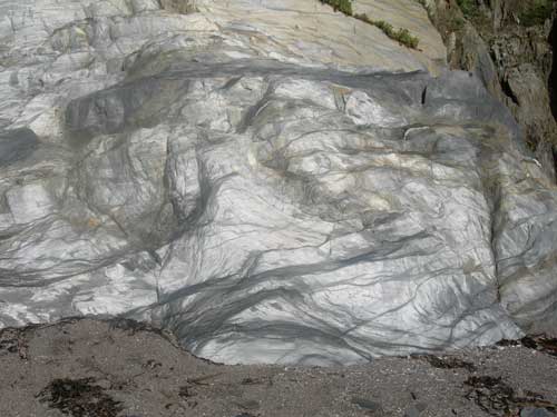
Aymer Cove – from Ringmore village.
§ Bovisand and Whitsand meet in this cove
§ Another variation on the Bovisand Formation to the South-west of the cove: ochre brown coloured veins of quarz run through in branching streaks shaped like plant roots.
§ Whitsand: fine-grained slatey – subordinate sandstone - dark grey mudrock;).
§ Another variation of Whitsand : - silicon dioxide clay material gives the southern cliffs a soft texture and a wonderful silver glow on such surfaces as reflect sunshine. The effect is like highly polished zinc – see photo.
Erme Estuary – Wormwell Beach
§ Whitsand Bay Formation. Yellow/orange shales ;dark veins and occasional quarz .
§ Volcanic intrusions – very dark with greenish tinge surface:, mafic ,
§ Jagged sky-line where the mafic rocks are exposed.
§ Also Breccias; intrusions into the sandstone with chert and flint ; large lenses of crystals
Burraton Quarry–
§ Variscan pressures - then bounce back reduces pressure – then melt then equilibrium.
§ Spotted zone i.e. metamorphic aureole; the marginal area around an intrusion.
§ Feldspars: and minute shiny crystalline particles within dense fine grained dark red/grey rocks.
§ Crystals – large oblong shapes; seen through a lens – orthoclase; the twinning effect.
Sheeps Tor
§ Typical Devon Tor country –granite blocks.
§ Frost erosion creates fractures that produce profuse scatters of shattered and layered granite.
Plymouth Mount Batten
§ Limestone to the right of the pier and Saltash Formation (overlying) to the left.
§ The limestone locally – that is at Plymouth Hoe – is crumpled and in knapps. Strong fizz
§ Underlying sea crust ruptured; large blocks fractured and tilted; dust and mud from the progeny settles into the depths; but the higher surfaces such as Plymouth of the up-ended blocks are in shallower and clearer waters. Tropical. Therefore limestone building conditions. Other South Devon Limestone’s are in the Torquay area and Haddon Hills.
§ Stromatoporoids within limestones. The limestone is otherwise grey with ochre–coloured veins. Looks blackish when under sea water. The lenses are created by gaps between the layers filling with varied solutions of sea water saturated with lime. The result looks like quartz but isn’t.