DETAILS OF DAY 3
The third day is officially a 'rest' day, giving an opportunity for shopping, visiting the many archaeological sites, or just relaxing beside the pool at the hotel. However, for those more energetic, there is an optional walk to an excellent viewpoint at Mount Adelphi. The name Adelfoi comes from the Greek word: Αδελφοί meaning 'brothers', a reference to the three adjacent peaks of the mountain.
'Classic Geology in Europe' gives a good description of the area, on pages 64 and 65:
Stop 3.3 Sheeted dykes and epidosites on the Madari Ridge north of Chandria.
"The Madari ridge allows examination of some of the very best exposures of sheeted dykes and epidosites in the Troodos ophiolite, in addition to providing some excellent near and far views. The half- or all-day walk begins and ends at a CYTA station, which is reached from the F915 between Chandria and Polystypos.
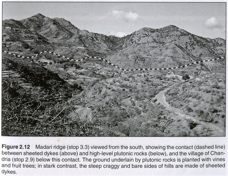
"This stop ideally involves 2-3 hours of walking in the mountains to the north of Chandria (see Fig. 2.12), although it can be cut shorter if necessary. Not only are the sheeted dykes at their best here, but it is one of the great walks in Cyprus, with wonderful views, especially on clear days in the spring. The turnoff for the Madari Ridge lies at the summit on the F915 between Chandria (see stop 2.9) to the west and Polystypos to the east, where there is a crossroads with roads to Agros (south) and to a Cyprus Telecommunications Authority (CYTA) station (northwest). Take the road for the CYTA station, which at first runs across relatively flat terrain for about 1 km and then starts to climb at a hairpin bend. A large bus will have to stop here, about 1 km from the start point of the main walk. The flat terrain contains outcrops of the very top of the plutonic sequence, but the base of the dykes lies close to the bottom of the hairpin bend. At a distance of 2 km from the crossroads, the metalled road ends at the entrance to the CYTA station and there is a parking area with information boards (36 499912 E, 38 67643 N).
"From the parking area, walk up the dirt road as it zig-zags through the sheeted dykes, in which there are sections both perpendicular and parallel to the dykes. In the sections perpendicular to the dykes, look for chilling relationships. In some of the sections parallel to the dykes, there are joint surfaces that expose a single chilled margin over an area of a few square metres. These chilled margins are in many places wavy and grooved in a series of parallel undulations. The orientation of the axes of these undulations probably represents the direction of intrusion of magma in the dyke, as can also be seen from the imbrication of vesicles near dyke margins. Note that the orientation of the undulations varies from dyke to dyke and is rarely vertical.
"On the other side of the road are spectacular views of a bare hillside made up entirely of sheeted dykes, capped by a fire lookout perched on a ridge crest. To the east, about 2 km away, is another bare hillside of sheeted dykes, and beyond that are hills receding into the distance, all capped by sheeted dykes, demonstrating the vast extent of the sheeteddyke sequence.
"At the end of the dirt road is an information board with a map of a network of walks traversing the area. From here take the path labelled "Doxa Soi 0 Theos" that climbs to the crest of the ridge and then leads along it. The path crosses excellent outcrops of sheeted dykes, with an occasional one altered to epidosite, and there are amazing views near and far: in the distance to the south is the Acrotiri salt lake southwest of Lemesos; to the north the view stretches across the Mesaoria Plain to the Kyrenia Range; to the east is the knobbly backbone of sheeted dykes stretching all the way to the Kionia peak, topped with a television station; to the west are rocks of the mantle sequence forming Mount Olympos, scarred by the abandoned asbestos mine. Closer, below the ridge to the south, is rolling country dotted with villages on the plutonic sequence; the contact between the plutonics and the sheeted dykes runs along the base of the ridge. To the north is a narrow outcrop of plutonic rocks in the valley below and yet more hills of sheeted dykes before the cover of the volcanic sequence starts in the low ground near the Mesaoria Plain.
"After 400m on the path there is a sign stating "excellent viewpoint" (36 499149 E, 38 68068 N), beyond which there is abundant replacement of sheeted dykes by epidosite. For the critical field observations that can be made on epidosites, refer to stop 3.8. The good epidosite outcrops continue for another 400m to a brown knob on the ridge just off the path (36498747 E, 3867912N), where the transect ends. The trail continues after this and it is possible to make a 10-12 km round-trip back to the parking place using the marked paths, which is highly recommended if time, energy and drinking water permit. If not, return to the information board below the fire lookout and from here walk back down the dirt road to the lower parking place. An alternative and more atmospheric return follows a way-marked path around the base of the peak capped by the fire lookout and back to the parking place across spectacular crags of sheeted dykes."
![]()
![]()
![]()